Weisel geodata
Weisel (Rheinland-Pfalz) is a seat of a fourth-order administrative division; located in Germany in Europe/Berlin (GMT+2) time zone. With population of 1,161 people, there are 6676 cities with bigger population in this country. Compared to other cities in Germany, 61% of cities are located further ↑North; 81% of cities are located further →East and 74.9% of cities have lower elevation than Weisel. Note1


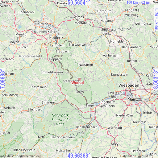
Weisel GPS coordinates[2]
50° 7' 0.012" North, 7° 48' 0" East
| Map corner | latitude | longitude |
|---|---|---|
| Upper-left | 50.56541°, | 7.09688° |
| Center: | 50.11667°, | 7.8° |
| Lower-right: | 49.66368°, | 8.50313° |
| Map W x H: | 100.3×100.3 km | = 62.3×62.3mi |
| max Lat: | 55.01917° ⇑61% North |
| Weisel: | 50.11667° |
| min Lat: | ⇓39% South 47.40724° |
| min Long | Weisel | max Long |
| 5.92978° | 7.8° | 14.98853° |
| W 19%⇐ | ⇒81% E |
Elevation
Elevation of Weisel is 397 m = 1302 ft, and this is 147.9 m = 485 ft above average elevation for this country.
| Max E: |
1256 m = 4121 ft | 25.1% |
| Weisel | 397 m 1302 ft | |
| Avg. | 249.1 m = 817 ft | |
Min E: |
-5 m = -16 ft | 74.9% |
See also: Germany elevation on elevation.city.
Geographical zone
Weisel is located in North temperate zone (between Tropic of Cancer and the Arctic Circle). Distance of this North polar circle is 1828.7 km =1136.3 mi to North.| Distance of | km | miles | from Weisel |
|---|---|---|---|
| North Pole | 4434.6 | 2755.5 | to North |
| Arctic Circle | 1828.7 | 1136.3 | to North |
| Tropic Cancer | 2966.5 | 1843.3 | to South |
| Equator | 5572.5 | 3462.6 | to South |


Nearby cities:
15 places around Weisel: (largest is in red/bold)
• Auel
6 km =3.7 mi,  336°
336°
• Bornich
2.7 km =1.7 mi,  294°
294°
• Dörscheid
4 km =2.5 mi,  242°
242°
• Kaub
4.2 km =2.6 mi,  221°
221°
• Lautert
6 km =3.7 mi,  23°
23°
• Lipporn
5.1 km =3.2 mi,  68°
68°
• Niederwallmenach
5.7 km =3.5 mi,  12°
12°
• Oberwallmenach
6 km =3.7 mi, 23°
• Oberwesel
5.4 km =3.4 mi,  259°
259°
• Patersberg
6 km =3.7 mi,  307°
307°
• Reichenberg
4.4 km =2.7 mi,  327°
327°
• Reitzenhain
3.9 km =2.4 mi, 342°
• Rettershain
4.4 km =2.7 mi,  32°
32°
• Sauerthal
3.8 km =2.4 mi,  156°
156°
• Welterod
6.2 km =3.9 mi, 72°
Sources, notices
• [Note1] Compared only with cities in Germany existing in our database
• [Src1] Map data: © OpenStreetMap contributors (CC-BY-SA)
• [Src2] Other city data from geonames.org with taken over terms of usage.
• [Src3] Geographical zone / Annual Mean Temperature by Robert A. Rohde @ Wikipedia
