Oberwesel geodata
Oberwesel (Rheinland-Pfalz) is a populated place; located in Germany in Europe/Berlin (GMT+2) time zone. With population of 3,128 people, there are 3891 cities with bigger population in this country. Compared to other cities in Germany, 61.1% of cities are located further ↑North; 82.6% of cities are located further →East and 70.2% of cities have higher elevation than Oberwesel. Note1
Administrative division(s):
- Level 1: Rheinland-Pfalz
- Level 3: Rhein-Hunsrück-Kreis
- Level 4: Oberwesel


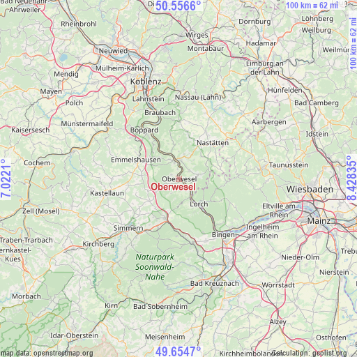
Oberwesel GPS coordinates[2]
50° 6' 27.972" North, 7° 43' 30.792" East
| Map corner | latitude | longitude |
|---|---|---|
| Upper-left | 50.5566°, | 7.0221° |
| Center: | 50.10777°, | 7.72522° |
| Lower-right: | 49.6547°, | 8.42835° |
| Map W x H: | 100.3×100.3 km | = 62.3×62.3mi |
| max Lat: | 55.01917° ⇑61.1% North |
| Oberwesel: | 50.10777° |
| min Lat: | ⇓38.9% South 47.40724° |
| min Long | Oberwesel | max Long |
| 5.92978° | 7.72522° | 14.98853° |
| W 17.4%⇐ | ⇒82.6% E |
Elevation
Elevation of Oberwesel is 90 m = 295 ft, and this is 159.1 m = 522 ft below average elevation for this country.
| Max E: |
1256 m = 4121 ft | 70.2% |
| Avg. | 249.1 m = 817 ft | |
| Oberwesel | 90 m = 295 ft | |
Min E: |
-5 m = -16 ft | 29.8% |
See also: Germany elevation on elevation.city.
Geographical zone
Oberwesel is located in North temperate zone (between Tropic of Cancer and the Arctic Circle). Distance of this North polar circle is 1829.7 km =1136.9 mi to North.| Distance of | km | miles | from Oberwesel |
|---|---|---|---|
| North Pole | 4435.6 | 2756.2 | to North |
| Arctic Circle | 1829.7 | 1136.9 | to North |
| Tropic Cancer | 2965.5 | 1842.7 | to South |
| Equator | 5571.5 | 3462 | to South |


Nearby cities:
15 places around Oberwesel: (largest is in red/bold)
• Bacharach
6.4 km =4 mi,  150°
150°
• Badenhard
6.6 km =4.1 mi,  278°
278°
• Bornich
3.6 km =2.2 mi,  53°
53°
• Damscheid
3.1 km =1.9 mi,  253°
253°
• Dörscheid
2 km =1.2 mi,  116°
116°
• Kaub
3.3 km =2.1 mi,  130°
130°
• Niederburg
2.1 km =1.3 mi,  298°
298°
• Patersberg
4.7 km =2.9 mi,  7°
7°
• Perscheid
4.9 km =3 mi,  201°
201°
• Reichenberg
5.5 km =3.4 mi,  32°
32°
• Reitzenhain
6.3 km =3.9 mi,  41°
41°
• Sankt Goar
4.7 km =2.9 mi,  344°
344°
• Sankt Goarshausen
5.7 km =3.5 mi,  351°
351°
• Urbar
2.9 km =1.8 mi, 347°
• Weisel
5.4 km =3.4 mi,  79°
79°
Sources, notices
• [Note1] Compared only with cities in Germany existing in our database
• [Src1] Map data: © OpenStreetMap contributors (CC-BY-SA)
• [Src2] Other city data from geonames.org with taken over terms of usage.
• [Src3] Geographical zone / Annual Mean Temperature by Robert A. Rohde @ Wikipedia
