Weigenheim geodata
Weigenheim (Bavaria) is a seat of a fourth-order administrative division; located in Germany in Europe/Berlin (GMT+2) time zone. With population of 978 people, there are 7253 cities with bigger population in this country. Compared to other cities in Germany, 74.3% of cities are located further ↑North; 54.6% of cities are located further ←West and 66.7% of cities have lower elevation than Weigenheim. Note1
Administrative division(s):
- Level 1: Bavaria
- Level 2: Regierungsbezirk Mittelfranken
- Level 3: Landkreis Neustadt an der Aisch-Bad Windsheim
- Level 4: Weigenheim


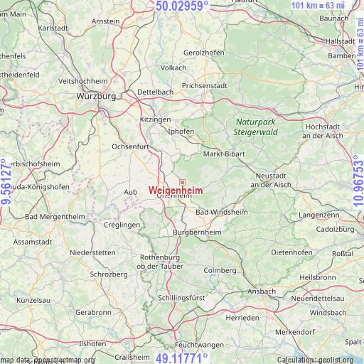
Weigenheim GPS coordinates[2]
49° 34' 32.808" North, 10° 15' 51.84" East
| Map corner | latitude | longitude |
|---|---|---|
| Upper-left | 50.02959°, | 9.56127° |
| Center: | 49.57578°, | 10.2644° |
| Lower-right: | 49.11771°, | 10.96753° |
| Map W x H: | 101.4×101.4 km | = 63×63mi |
| max Lat: | 55.01917° ⇑74.3% North |
| Weigenheim: | 49.57578° |
| min Lat: | ⇓25.7% South 47.40724° |
| min Long | Weigenheim | max Long |
| 5.92978° | 10.2644° | 14.98853° |
| W 54.6%⇐ | ⇒45.4% E |
Elevation
Elevation of Weigenheim is 333 m = 1093 ft, and this is 83.9 m = 275 ft above average elevation for this country.
| Max E: |
1256 m = 4121 ft | 33.3% |
| Weigenheim | 333 m 1093 ft | |
| Avg. | 249.1 m = 817 ft | |
Min E: |
-5 m = -16 ft | 66.7% |
See also: Germany elevation on elevation.city.
Geographical zone
Weigenheim is located in North temperate zone (between Tropic of Cancer and the Arctic Circle). Distance of this North polar circle is 1888.9 km =1173.7 mi to North.| Distance of | km | miles | from Weigenheim |
|---|---|---|---|
| North Pole | 4494.8 | 2792.9 | to North |
| Arctic Circle | 1888.9 | 1173.7 | to North |
| Tropic Cancer | 2906.4 | 1806 | to South |
| Equator | 5512.3 | 3425.2 | to South |


Nearby cities:
15 places around Weigenheim: (largest is in red/bold)
• Ergersheim
8.2 km =5.1 mi,  142°
142°
• Gollhofen
5.3 km =3.3 mi,  261°
261°
• Hemmersheim
12.2 km =7.6 mi, 263°
• Ippesheim
4.1 km =2.5 mi,  316°
316°
• Markt Einersheim
12.5 km =7.8 mi,  9°
9°
• Markt Nordheim
6.8 km =4.2 mi,  75°
75°
• Martinsheim
9.9 km =6.2 mi,  302°
302°
• Oberickelsheim
9.8 km =6.1 mi,  285°
285°
• Obernbreit
11.7 km =7.3 mi, 321°
• Ohrenbach
12.3 km =7.6 mi,  198°
198°
• Seinsheim
7.9 km =4.9 mi,  336°
336°
• Simmershofen
10.6 km =6.6 mi,  243°
243°
• Sugenheim
12.7 km =7.9 mi, 76°
• Uffenheim
4.2 km =2.6 mi,  212°
212°
• Willanzheim
11.8 km =7.3 mi,  348°
348°
Sources, notices
• [Note1] Compared only with cities in Germany existing in our database
• [Src1] Map data: © OpenStreetMap contributors (CC-BY-SA)
• [Src2] Other city data from geonames.org with taken over terms of usage.
• [Src3] Geographical zone / Annual Mean Temperature by Robert A. Rohde @ Wikipedia
