Obernbreit geodata
Obernbreit (Bavaria) is a populated place; located in Germany in Europe/Berlin (GMT+2) time zone. With population of 1,829 people, there are 5299 cities with bigger population in this country. Compared to other cities in Germany, 72.3% of cities are located further ↑North; 52.7% of cities are located further ←West and 53.7% of cities have higher elevation than Obernbreit. Note1
Administrative division(s):
- Level 1: Bavaria
- Level 2: Regierungsbezirk Unterfranken
- Level 3: Landkreis Kitzingen
- Level 4: Obernbreit, Markt


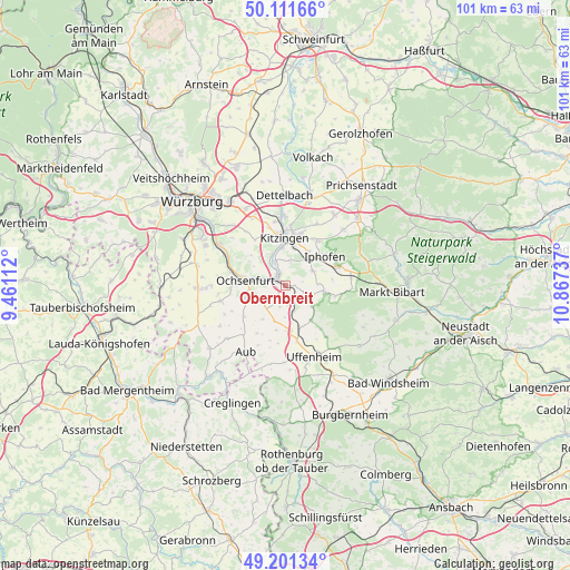
Obernbreit GPS coordinates[2]
49° 39' 31.068" North, 10° 9' 51.264" East
| Map corner | latitude | longitude |
|---|---|---|
| Upper-left | 50.11166°, | 9.46112° |
| Center: | 49.65863°, | 10.16424° |
| Lower-right: | 49.20134°, | 10.86737° |
| Map W x H: | 101.2×101.2 km | = 62.9×62.9mi |
| max Lat: | 55.01917° ⇑72.3% North |
| Obernbreit: | 49.65863° |
| min Lat: | ⇓27.7% South 47.40724° |
| min Long | Obernbreit | max Long |
| 5.92978° | 10.16424° | 14.98853° |
| W 52.7%⇐ | ⇒47.3% E |
Elevation
Elevation of Obernbreit is 199 m = 653 ft, and this is 50.1 m = 164 ft below average elevation for this country.
| Max E: |
1256 m = 4121 ft | 53.7% |
| Avg. | 249.1 m = 817 ft | |
| Obernbreit | 199 m = 653 ft | |
Min E: |
-5 m = -16 ft | 46.3% |
See also: Germany elevation on elevation.city.
Geographical zone
Obernbreit is located in North temperate zone (between Tropic of Cancer and the Arctic Circle). Distance of this North polar circle is 1879.7 km =1168 mi to North.| Distance of | km | miles | from Obernbreit |
|---|---|---|---|
| North Pole | 4485.5 | 2787.2 | to North |
| Arctic Circle | 1879.7 | 1168 | to North |
| Tropic Cancer | 2915.6 | 1811.7 | to South |
| Equator | 5521.5 | 3430.9 | to South |


Nearby cities:
15 places around Obernbreit: (largest is in red/bold)
• Frickenhausen
5.3 km =3.3 mi,  284°
284°
• Iphofen
8.5 km =5.3 mi,  54°
54°
• Ippesheim
7.7 km =4.8 mi,  144°
144°
• Kitzingen
9.1 km =5.7 mi,  353°
353°
• Mainbernheim
6.8 km =4.2 mi,  35°
35°
• Marktbreit
1.4 km =0.9 mi,  302°
302°
• Marktsteft
4.6 km =2.9 mi,  334°
334°
• Martinsheim
4.1 km =2.5 mi,  195°
195°
• Oberickelsheim
6.9 km =4.3 mi, 198°
• Ochsenfurt
7.4 km =4.6 mi,  274°
274°
• Rödelsee
9.6 km =6 mi, 36°
• Segnitz
2.1 km =1.3 mi,  316°
316°
• Seinsheim
4.5 km =2.8 mi,  116°
116°
• Sulzfeld am Main
5.8 km =3.6 mi,  336°
336°
• Willanzheim
5.5 km =3.4 mi,  64°
64°
Sources, notices
• [Note1] Compared only with cities in Germany existing in our database
• [Src1] Map data: © OpenStreetMap contributors (CC-BY-SA)
• [Src2] Other city data from geonames.org with taken over terms of usage.
• [Src3] Geographical zone / Annual Mean Temperature by Robert A. Rohde @ Wikipedia
