Ohrenbach geodata
Ohrenbach (Bavaria) is a seat of a fourth-order administrative division; located in Germany in Europe/Berlin (GMT+2) time zone. With population of 663 people, there are 8503 cities with bigger population in this country. Compared to other cities in Germany, 76.2% of cities are located further ↑North; 53.5% of cities are located further ←West and 76.4% of cities have lower elevation than Ohrenbach. Note1
Administrative division(s):
- Level 1: Bavaria
- Level 2: Regierungsbezirk Mittelfranken
- Level 3: Landkreis Ansbach
- Level 4: Ohrenbach


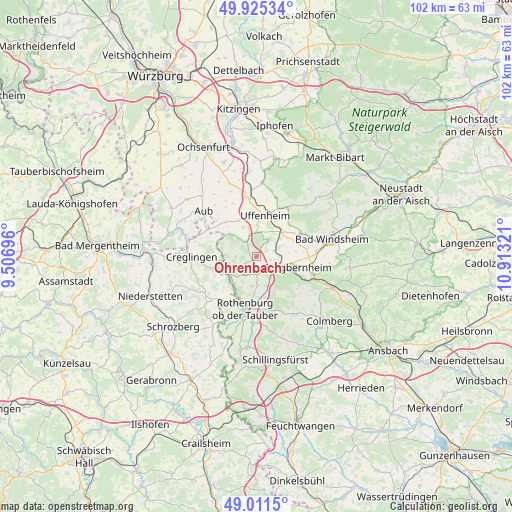
Ohrenbach GPS coordinates[2]
49° 28' 13.98" North, 10° 12' 36.288" East
| Map corner | latitude | longitude |
|---|---|---|
| Upper-left | 49.92534°, | 9.50696° |
| Center: | 49.47055°, | 10.21008° |
| Lower-right: | 49.0115°, | 10.91321° |
| Map W x H: | 101.6×101.6 km | = 63.1×63.1mi |
| max Lat: | 55.01917° ⇑76.2% North |
| Ohrenbach: | 49.47055° |
| min Lat: | ⇓23.8% South 47.40724° |
| min Long | Ohrenbach | max Long |
| 5.92978° | 10.21008° | 14.98853° |
| W 53.5%⇐ | ⇒46.5% E |
Elevation
Elevation of Ohrenbach is 408 m = 1339 ft, and this is 158.9 m = 521 ft above average elevation for this country.
| Max E: |
1256 m = 4121 ft | 23.6% |
| Ohrenbach | 408 m 1339 ft | |
| Avg. | 249.1 m = 817 ft | |
Min E: |
-5 m = -16 ft | 76.4% |
See also: Germany elevation on elevation.city.
Geographical zone
Ohrenbach is located in North temperate zone (between Tropic of Cancer and the Arctic Circle). Distance of this North polar circle is 1900.6 km =1181 mi to North.| Distance of | km | miles | from Ohrenbach |
|---|---|---|---|
| North Pole | 4506.5 | 2800.2 | to North |
| Arctic Circle | 1900.6 | 1181 | to North |
| Tropic Cancer | 2894.7 | 1798.7 | to South |
| Equator | 5500.6 | 3417.9 | to South |


Nearby cities:
15 places around Ohrenbach: (largest is in red/bold)
• Adelshofen
5.2 km =3.2 mi,  217°
217°
• Burgbernheim
8.5 km =5.3 mi,  104°
104°
• Creglingen
12.9 km =8 mi,  269°
269°
• Ergersheim
10.3 km =6.4 mi,  60°
60°
• Gallmersgarten
4.7 km =2.9 mi,  119°
119°
• Gollhofen
11 km =6.8 mi,  353°
353°
• Illesheim
12.4 km =7.7 mi,  85°
85°
• Marktbergel
11.6 km =7.2 mi,  106°
106°
• Neusitz
11 km =6.8 mi,  174°
174°
• Rothenburg ob der Tauber
10.3 km =6.4 mi,  189°
189°
• Simmershofen
8.9 km =5.5 mi,  321°
321°
• Steinsfeld
6 km =3.7 mi,  175°
175°
• Uffenheim
8.3 km =5.2 mi,  11°
11°
• Weigenheim
12.3 km =7.6 mi,  18°
18°
• Windelsbach
10.2 km =6.3 mi,  140°
140°
Sources, notices
• [Note1] Compared only with cities in Germany existing in our database
• [Src1] Map data: © OpenStreetMap contributors (CC-BY-SA)
• [Src2] Other city data from geonames.org with taken over terms of usage.
• [Src3] Geographical zone / Annual Mean Temperature by Robert A. Rohde @ Wikipedia
