Dreggers geodata
Dreggers (Schleswig-Holstein) is a seat of a fourth-order administrative division; located in Germany in Europe/Berlin (GMT+2) time zone. With population of 56 people, there are 10951 cities with bigger population in this country. Compared to other cities in Germany, 91% of cities are located further ↓South; 56.3% of cities are located further ←West and 85.4% of cities have higher elevation than Dreggers. Note1


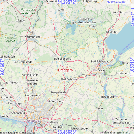
Dreggers GPS coordinates[2]
53° 52' 59.988" North, 10° 21' 0" East
| Map corner | latitude | longitude |
|---|---|---|
| Upper-left | 54.29572°, | 9.64687° |
| Center: | 53.88333°, | 10.35° |
| Lower-right: | 53.46683°, | 11.05313° |
| Map W x H: | 92.2×92.2 km | = 57.3×57.3mi |
| max Lat: | 55.01917° ⇑9% North |
| Dreggers: | 53.88333° |
| min Lat: | ⇓91% South 47.40724° |
| min Long | Dreggers | max Long |
| 5.92978° | 10.35° | 14.98853° |
| W 56.3%⇐ | ⇒43.7% E |
Elevation
Elevation of Dreggers is 34 m = 112 ft, and this is 215.1 m = 706 ft below average elevation for this country.
| Max E: |
1256 m = 4121 ft | 85.4% |
| Avg. | 249.1 m = 817 ft | |
| Dreggers | 34 m = 112 ft | |
Min E: |
-5 m = -16 ft | 14.6% |
See also: Germany elevation on elevation.city.
Geographical zone
Dreggers is located in North temperate zone (between Tropic of Cancer and the Arctic Circle). Distance of this North polar circle is 1409.9 km =876.1 mi to North.| Distance of | km | miles | from Dreggers |
|---|---|---|---|
| North Pole | 4015.8 | 2495.3 | to North |
| Arctic Circle | 1409.9 | 876.1 | to North |
| Tropic Cancer | 3385.3 | 2103.5 | to South |
| Equator | 5991.3 | 3722.8 | to South |


Nearby cities:
15 places around Dreggers: (largest is in red/bold)
• Bad Segeberg
7.4 km =4.6 mi,  334°
334°
• Bahrenhof
2.2 km =1.4 mi,  90°
90°
• Bebensee
3.3 km =2.1 mi,  270°
270°
• Bühnsdorf
2.2 km =1.4 mi, 90°
• Geschendorf
7.4 km =4.6 mi,  55°
55°
• Högersdorf
5.7 km =3.5 mi,  310°
310°
• Klein Gladebrügge
4.3 km =2.7 mi, 329°
• Leezen
6.8 km =4.2 mi,  254°
254°
• Neuengörs
2.9 km =1.8 mi,  49°
49°
• Neversdorf
4.7 km =2.9 mi, 247°
• Schieren
7.2 km =4.5 mi,  21°
21°
• Schwissel
3.8 km =2.4 mi,  299°
299°
• Steinfeld
7.5 km =4.7 mi,  137°
137°
• Traventhal
2.9 km =1.8 mi, 310°
• Weede
4.6 km =2.9 mi, 17°
Sources, notices
• [Note1] Compared only with cities in Germany existing in our database
• [Src1] Map data: © OpenStreetMap contributors (CC-BY-SA)
• [Src2] Other city data from geonames.org with taken over terms of usage.
• [Src3] Geographical zone / Annual Mean Temperature by Robert A. Rohde @ Wikipedia
