Wasserleben geodata
Wasserleben (Saxony-Anhalt) is a populated place; located in Germany in Europe/Berlin (GMT+2) time zone. With population of 1,509 people, there are 5865 cities with bigger population in this country. Compared to other cities in Germany, 71.3% of cities are located further ↓South; 63.3% of cities are located further ←West and 59.6% of cities have higher elevation than Wasserleben. Note1


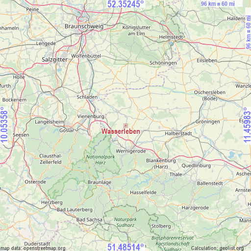
Wasserleben GPS coordinates[2]
51° 55' 15.204" North, 10° 45' 24.12" East
| Map corner | latitude | longitude |
|---|---|---|
| Upper-left | 52.35245°, | 10.05358° |
| Center: | 51.92089°, | 10.7567° |
| Lower-right: | 51.48514°, | 11.45983° |
| Map W x H: | 96.4×96.4 km | = 59.9×59.9mi |
| max Lat: | 55.01917° ⇑28.7% North |
| Wasserleben: | 51.92089° |
| min Lat: | ⇓71.3% South 47.40724° |
| min Long | Wasserleben | max Long |
| 5.92978° | 10.7567° | 14.98853° |
| W 63.3%⇐ | ⇒36.7% E |
Elevation
Elevation of Wasserleben is 156 m = 512 ft, and this is 93.1 m = 305 ft below average elevation for this country.
| Max E: |
1256 m = 4121 ft | 59.6% |
| Avg. | 249.1 m = 817 ft | |
| Wasserleben | 156 m = 512 ft | |
Min E: |
-5 m = -16 ft | 40.4% |
See also: Germany elevation on elevation.city.
Geographical zone
Wasserleben is located in North temperate zone (between Tropic of Cancer and the Arctic Circle). Distance of this North polar circle is 1628.1 km =1011.7 mi to North.| Distance of | km | miles | from Wasserleben |
|---|---|---|---|
| North Pole | 4234 | 2630.9 | to North |
| Arctic Circle | 1628.1 | 1011.7 | to North |
| Tropic Cancer | 3167.1 | 1967.9 | to South |
| Equator | 5773.1 | 3587.2 | to South |


Nearby cities:
15 places around Wasserleben: (largest is in red/bold)
• Abbenrode
9 km =5.6 mi,  275°
275°
• Berßel
3.7 km =2.3 mi,  1°
1°
• Danstedt
8.9 km =5.5 mi,  96°
96°
• Darlingerode
8.4 km =5.2 mi,  192°
192°
• Drübeck
7.4 km =4.6 mi,  200°
200°
• Heudeber
6.3 km =3.9 mi,  109°
109°
• Huy-Neinstedt
11.9 km =7.4 mi,  65°
65°
• Ilsenburg
8.1 km =5 mi,  221°
221°
• Langeln
2.8 km =1.7 mi, 111°
• Lüttgenrode
8.1 km =5 mi,  309°
309°
• Osterwieck
6.3 km =3.9 mi,  329°
329°
• Reddeber
6.9 km =4.3 mi,  151°
151°
• Stapelburg
6.8 km =4.2 mi,  250°
250°
• Veckenstedt
2.8 km =1.7 mi, 217°
• Wernigerode
9.5 km =5.9 mi,  169°
169°
Sources, notices
• [Note1] Compared only with cities in Germany existing in our database
• [Src1] Map data: © OpenStreetMap contributors (CC-BY-SA)
• [Src2] Other city data from geonames.org with taken over terms of usage.
• [Src3] Geographical zone / Annual Mean Temperature by Robert A. Rohde @ Wikipedia
