Wernigerode geodata
Wernigerode (Saxony-Anhalt) is a populated place; located in Germany in Europe/Berlin (GMT+2) time zone. With population of 34,463 people, there are 389 cities with bigger population in this country. Compared to other cities in Germany, 70.3% of cities are located further ↓South; 63.7% of cities are located further ←West and 51.6% of cities have lower elevation than Wernigerode. Note1


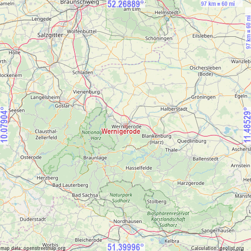
Wernigerode GPS coordinates[2]
51° 50' 11.472" North, 10° 46' 55.776" East
| Map corner | latitude | longitude |
|---|---|---|
| Upper-left | 52.26889°, | 10.07904° |
| Center: | 51.83652°, | 10.78216° |
| Lower-right: | 51.39996°, | 11.48529° |
| Map W x H: | 96.6×96.6 km | = 60×60mi |
| max Lat: | 55.01917° ⇑29.7% North |
| Wernigerode: | 51.83652° |
| min Lat: | ⇓70.3% South 47.40724° |
| min Long | Wernigerode | max Long |
| 5.92978° | 10.78216° | 14.98853° |
| W 63.7%⇐ | ⇒36.3% E |
Elevation
Elevation of Wernigerode is 237 m = 778 ft, and this is 12.1 m = 40 ft below average elevation for this country.
| Max E: |
1256 m = 4121 ft | 48.4% |
| Avg. | 249.1 m = 817 ft | |
| Wernigerode | 237 m = 778 ft | |
Min E: |
-5 m = -16 ft | 51.6% |
See also: Germany elevation on elevation.city.
Geographical zone
Wernigerode is located in North temperate zone (between Tropic of Cancer and the Arctic Circle). Distance of this North polar circle is 1637.5 km =1017.5 mi to North.| Distance of | km | miles | from Wernigerode |
|---|---|---|---|
| North Pole | 4243.4 | 2636.7 | to North |
| Arctic Circle | 1637.5 | 1017.5 | to North |
| Tropic Cancer | 3157.8 | 1962.2 | to South |
| Equator | 5763.7 | 3581.4 | to South |


Nearby cities:
15 places around Wernigerode: (largest is in red/bold)
• Danstedt
11 km =6.8 mi,  40°
40°
• Darlingerode
3.7 km =2.3 mi,  288°
288°
• Derenburg
9.6 km =6 mi,  66°
66°
• Drübeck
5 km =3.1 mi,  298°
298°
• Elbingerode
7.5 km =4.7 mi,  167°
167°
• Heimburg
9 km =5.6 mi,  99°
99°
• Heudeber
8.4 km =5.2 mi,  29°
29°
• Ilsenburg
7.9 km =4.9 mi, 295°
• Königshütte
10.4 km =6.5 mi,  186°
186°
• Langeln
8.4 km =5.2 mi,  5°
5°
• Reddeber
3.6 km =2.2 mi,  24°
24°
• Rübeland
10 km =6.2 mi,  153°
153°
• Stapelburg
10.9 km =6.8 mi,  310°
310°
• Veckenstedt
8 km =5 mi,  334°
334°
• Wasserleben
9.5 km =5.9 mi,  349°
349°
Sources, notices
• [Note1] Compared only with cities in Germany existing in our database
• [Src1] Map data: © OpenStreetMap contributors (CC-BY-SA)
• [Src2] Other city data from geonames.org with taken over terms of usage.
• [Src3] Geographical zone / Annual Mean Temperature by Robert A. Rohde @ Wikipedia
