Darlingerode geodata
Darlingerode (Saxony-Anhalt) is a populated place; located in Germany in Europe/Berlin (GMT+2) time zone. With population of 2,321 people, there are 4646 cities with bigger population in this country. Compared to other cities in Germany, 70.5% of cities are located further ↓South; 62.9% of cities are located further ←West and 56% of cities have lower elevation than Darlingerode. Note1
Administrative division(s):
- Level 1: Saxony-Anhalt
- Level 3: Landkreis Harz
- Level 4: Ilsenburg (Harz)


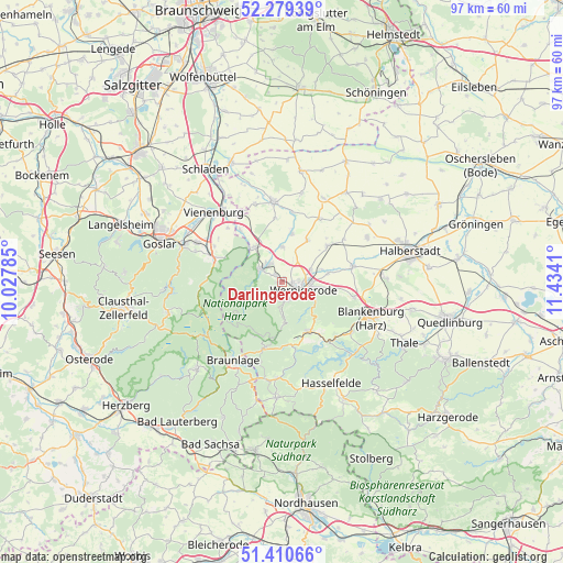
Darlingerode GPS coordinates[2]
51° 50' 49.632" North, 10° 43' 51.492" East
| Map corner | latitude | longitude |
|---|---|---|
| Upper-left | 52.27939°, | 10.02785° |
| Center: | 51.84712°, | 10.73097° |
| Lower-right: | 51.41066°, | 11.4341° |
| Map W x H: | 96.6×96.6 km | = 60×60mi |
| max Lat: | 55.01917° ⇑29.5% North |
| Darlingerode: | 51.84712° |
| min Lat: | ⇓70.5% South 47.40724° |
| min Long | Darlingerode | max Long |
| 5.92978° | 10.73097° | 14.98853° |
| W 62.9%⇐ | ⇒37.1% E |
Elevation
Elevation of Darlingerode is 266 m = 873 ft, and this is 16.9 m = 55 ft above average elevation for this country.
| Max E: |
1256 m = 4121 ft | 44% |
| Darlingerode | 266 m 873 ft | |
| Avg. | 249.1 m = 817 ft | |
Min E: |
-5 m = -16 ft | 56% |
See also: Germany elevation on elevation.city.
Geographical zone
Darlingerode is located in North temperate zone (between Tropic of Cancer and the Arctic Circle). Distance of this North polar circle is 1636.3 km =1016.7 mi to North.| Distance of | km | miles | from Darlingerode |
|---|---|---|---|
| North Pole | 4242.2 | 2636 | to North |
| Arctic Circle | 1636.3 | 1016.7 | to North |
| Tropic Cancer | 3158.9 | 1962.8 | to South |
| Equator | 5764.9 | 3582.1 | to South |


Nearby cities:
15 places around Darlingerode: (largest is in red/bold)
• Abbenrode
11.6 km =7.2 mi,  321°
321°
• Berßel
12.1 km =7.5 mi,  8°
8°
• Drübeck
1.5 km =0.9 mi, 324°
• Elbingerode
10 km =6.2 mi,  148°
148°
• Elend
11.8 km =7.3 mi,  194°
194°
• Heudeber
9.9 km =6.2 mi,  51°
51°
• Ilsenburg
4.2 km =2.6 mi,  301°
301°
• Königshütte
11.8 km =7.3 mi,  168°
168°
• Langeln
8.4 km =5.2 mi,  31°
31°
• Reddeber
5.5 km =3.4 mi,  67°
67°
• Schierke
10.4 km =6.5 mi,  207°
207°
• Stapelburg
7.6 km =4.7 mi, 321°
• Veckenstedt
6 km =3.7 mi,  0°
0°
• Wasserleben
8.4 km =5.2 mi, 12°
• Wernigerode
3.7 km =2.3 mi,  108°
108°
Sources, notices
• [Note1] Compared only with cities in Germany existing in our database
• [Src1] Map data: © OpenStreetMap contributors (CC-BY-SA)
• [Src2] Other city data from geonames.org with taken over terms of usage.
• [Src3] Geographical zone / Annual Mean Temperature by Robert A. Rohde @ Wikipedia
