Brüggen geodata
Brüggen (North Rhine-Westphalia) is a seat of a fourth-order administrative division; located in Germany in Europe/Berlin (GMT+2) time zone. With population of 16,105 people, there are 993 cities with bigger population in this country. Compared to other cities in Germany, 62.2% of cities are located further ↓South; 99.7% of cities are located further →East and 81% of cities have higher elevation than Brüggen. Note1
Administrative division(s):
- Level 1: North Rhine-Westphalia
- Level 2: Düsseldorf District
- Level 3: Kreis Viersen
- Level 4: Brüggen


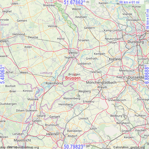
Brüggen GPS coordinates[2]
51° 14' 25.908" North, 6° 11' 1.536" East
| Map corner | latitude | longitude |
|---|---|---|
| Upper-left | 51.67862°, | 5.48063° |
| Center: | 51.24053°, | 6.18376° |
| Lower-right: | 50.79823°, | 6.88688° |
| Map W x H: | 97.9×97.9 km | = 60.8×60.8mi |
| max Lat: | 55.01917° ⇑37.8% North |
| Brüggen: | 51.24053° |
| min Lat: | ⇓62.2% South 47.40724° |
| min Long | Brüggen | max Long |
| 5.92978° | 6.18376° | 14.98853° |
| W 0.3%⇐ | ⇒99.7% E |
Elevation
Elevation of Brüggen is 44 m = 144 ft, and this is 205.1 m = 673 ft below average elevation for this country.
| Max E: |
1256 m = 4121 ft | 81% |
| Avg. | 249.1 m = 817 ft | |
| Brüggen | 44 m = 144 ft | |
Min E: |
-5 m = -16 ft | 19% |
See also: Germany elevation on elevation.city.
Geographical zone
Brüggen is located in North temperate zone (between Tropic of Cancer and the Arctic Circle). Distance of this North polar circle is 1703.8 km =1058.7 mi to North.| Distance of | km | miles | from Brüggen |
|---|---|---|---|
| North Pole | 4309.6 | 2677.9 | to North |
| Arctic Circle | 1703.8 | 1058.7 | to North |
| Tropic Cancer | 3091.5 | 1921 | to South |
| Equator | 5697.4 | 3540.2 | to South |


Nearby cities:
15 places around Brüggen: (largest is in red/bold)
• Erkelenz
20.1 km =12.5 mi,  152°
152°
• Grefrath
15.2 km =9.4 mi,  45°
45°
• Heinsberg
20.5 km =12.7 mi,  196°
196°
• Hückelhoven
20.8 km =12.9 mi,  171°
171°
• Kempen
21.4 km =13.3 mi, 49°
• Mönchengladbach
19 km =11.8 mi,  108°
108°
• Nettetal
10.9 km =6.8 mi,  39°
39°
• Niederkrüchten
5.1 km =3.2 mi, 153°
• Schwalmtal
6.4 km =4 mi, 114°
• Straelen
23.1 km =14.4 mi,  14°
14°
• Tönisvorst
23.4 km =14.5 mi,  67°
67°
• Viersen
14.7 km =9.1 mi,  84°
84°
• Wachtendonk
21.6 km =13.4 mi,  29°
29°
• Wassenberg
15.7 km =9.8 mi,  187°
187°
• Wegberg
13 km =8.1 mi, 147°
Sources, notices
• [Note1] Compared only with cities in Germany existing in our database
• [Src1] Map data: © OpenStreetMap contributors (CC-BY-SA)
• [Src2] Other city data from geonames.org with taken over terms of usage.
• [Src3] Geographical zone / Annual Mean Temperature by Robert A. Rohde @ Wikipedia
