Wannsee geodata
Wannsee (Berlin) is a section of populated place; located in Germany in Europe/Berlin (GMT+2) time zone. With population of 9,437 people, there are 1713 cities with bigger population in this country. Compared to other cities in Germany, 76.4% of cities are located further ↓South; 93.4% of cities are located further ←West and 82.8% of cities have higher elevation than Wannsee. Note1


Wannsee GPS coordinates[2]
52° 25' 8.94" North, 13° 9' 19.116" East
| Map corner | latitude | longitude |
|---|---|---|
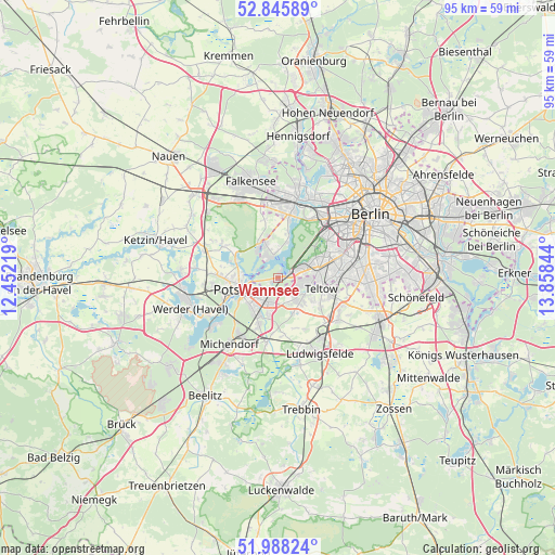
| Upper-left | 52.84589°, | 12.45219° |
| Center: | 52.41915°, | 13.15531° |
| Lower-right: | 51.98824°, | 13.85844° |
| Map W x H: | 95.4×95.4 km | = 59.3×59.3mi |
| max Lat: | 55.01917° ⇑23.6% North |
| Wannsee: | 52.41915° |
| min Lat: | ⇓76.4% South 47.40724° |
| min Long | Wannsee | max Long |
| 5.92978° | 13.15531° | 14.98853° |
| W 93.4%⇐ | ⇒6.6% E |
Elevation
Elevation of Wannsee is 40 m = 131 ft, and this is 209.1 m = 686 ft below average elevation for this country.
| Max E: |
1256 m = 4121 ft | 82.8% |
| Avg. | 249.1 m = 817 ft | |
| Wannsee | 40 m = 131 ft | |
Min E: |
-5 m = -16 ft | 17.2% |
See also: Germany elevation on elevation.city.
Geographical zone
Wannsee is located in North temperate zone (between Tropic of Cancer and the Arctic Circle). Distance of this North polar circle is 1572.7 km =977.2 mi to North.| Distance of | km | miles | from Wannsee |
|---|---|---|---|
| North Pole | 4178.6 | 2596.5 | to North |
| Arctic Circle | 1572.7 | 977.2 | to North |
| Tropic Cancer | 3222.5 | 2002.4 | to South |
| Equator | 5828.5 | 3621.7 | to South |


Nearby cities:
15 places around Wannsee: (largest is in red/bold)
• Dahlem
9.9 km =6.2 mi,  64°
64°
• Gatow
7.4 km =4.6 mi,  14°
14°
• Großbeeren
12.5 km =7.8 mi,  122°
122°
• Grunewald
10.3 km =6.4 mi,  46°
46°
• Halensee
12.4 km =7.7 mi, 50°
• Kladow
4 km =2.5 mi,  349°
349°
• Kleinmachnow
4.9 km =3 mi,  104°
104°
• Lichterfelde
10.4 km =6.5 mi,  81°
81°
• Nikolassee
3.5 km =2.2 mi, 61°
• Potsdam
6.5 km =4 mi,  249°
249°
• Schmargendorf
11.1 km =6.9 mi, 55°
• Stahnsdorf
5.8 km =3.6 mi,  133°
133°
• Teltow
7.3 km =4.5 mi, 104°
• Wilhelmstadt
11.8 km =7.3 mi, 7°
• Zehlendorf
6.6 km =4.1 mi, 76°
In other languages:
- In France: Berlin-Wannsee
- In German: Berlin-Wannsee
- In Russian: Ванзе́, Ванзе́е
- In Chinese: 万湖
Sources, notices
• [Note1] Compared only with cities in Germany existing in our database
• [Src1] Map data: © OpenStreetMap contributors (CC-BY-SA)
• [Src2] Other city data from geonames.org with taken over terms of usage.
• [Src3] Geographical zone / Annual Mean Temperature by Robert A. Rohde @ Wikipedia
