Stahnsdorf geodata
Stahnsdorf (Brandenburg) is a seat of a fourth-order administrative division; located in Germany in Europe/Berlin (GMT+2) time zone. With population of 12,964 people, there are 1242 cities with bigger population in this country. Compared to other cities in Germany, 76% of cities are located further ↓South; 93.8% of cities are located further ←West and 81.4% of cities have higher elevation than Stahnsdorf. Note1
Administrative division(s):
- Level 1: Brandenburg
- Level 3: Landkreis Potsdam-Mittelmark
- Level 4: Stahnsdorf


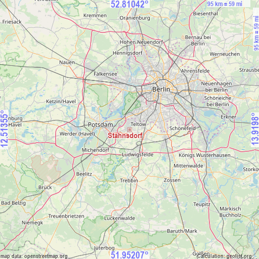
Stahnsdorf GPS coordinates[2]
52° 22' 59.988" North, 13° 13' 0.012" East
| Map corner | latitude | longitude |
|---|---|---|
| Upper-left | 52.81042°, | 12.51355° |
| Center: | 52.38333°, | 13.21667° |
| Lower-right: | 51.95207°, | 13.9198° |
| Map W x H: | 95.4×95.4 km | = 59.3×59.3mi |
| max Lat: | 55.01917° ⇑24% North |
| Stahnsdorf: | 52.38333° |
| min Lat: | ⇓76% South 47.40724° |
| min Long | Stahnsdorf | max Long |
| 5.92978° | 13.21667° | 14.98853° |
| W 93.8%⇐ | ⇒6.2% E |
Elevation
Elevation of Stahnsdorf is 43 m = 141 ft, and this is 206.1 m = 676 ft below average elevation for this country.
| Max E: |
1256 m = 4121 ft | 81.4% |
| Avg. | 249.1 m = 817 ft | |
| Stahnsdorf | 43 m = 141 ft | |
Min E: |
-5 m = -16 ft | 18.6% |
See also: Germany elevation on elevation.city.
Geographical zone
Stahnsdorf is located in North temperate zone (between Tropic of Cancer and the Arctic Circle). Distance of this North polar circle is 1576.7 km =979.7 mi to North.| Distance of | km | miles | from Stahnsdorf |
|---|---|---|---|
| North Pole | 4182.6 | 2598.9 | to North |
| Arctic Circle | 1576.7 | 979.7 | to North |
| Tropic Cancer | 3218.6 | 1999.9 | to South |
| Equator | 5824.5 | 3619.2 | to South |


Nearby cities:
15 places around Stahnsdorf: (largest is in red/bold)
• Dahlem
9.6 km =6 mi,  29°
29°
• Gatow
11.3 km =7 mi,  348°
348°
• Großbeeren
6.9 km =4.3 mi,  113°
113°
• Kladow
9.3 km =5.8 mi,  328°
328°
• Kleinmachnow
2.8 km =1.7 mi,  11°
11°
• Lankwitz
10.6 km =6.6 mi,  56°
56°
• Lichterfelde
8.3 km =5.2 mi,  47°
47°
• Ludwigsfelde
9.3 km =5.8 mi,  164°
164°
• Marienfelde
10.9 km =6.8 mi,  68°
68°
• Nikolassee
5.8 km =3.6 mi, 349°
• Potsdam
10.4 km =6.5 mi,  279°
279°
• Steglitz
11.2 km =7 mi,  44°
44°
• Teltow
3.7 km =2.3 mi, 53°
• Wannsee
5.8 km =3.6 mi,  313°
313°
• Zehlendorf
6 km =3.7 mi,  22°
22°
Sources, notices
• [Note1] Compared only with cities in Germany existing in our database
• [Src1] Map data: © OpenStreetMap contributors (CC-BY-SA)
• [Src2] Other city data from geonames.org with taken over terms of usage.
• [Src3] Geographical zone / Annual Mean Temperature by Robert A. Rohde @ Wikipedia
