Teltow geodata
Teltow (Brandenburg) is a populated place; located in Germany in Europe/Berlin (GMT+2) time zone. With population of 19,530 people, there are 794 cities with bigger population in this country. Compared to other cities in Germany, 76.2% of cities are located further ↓South; 94% of cities are located further ←West and 83.2% of cities have higher elevation than Teltow. Note1
Administrative division(s):
- Level 1: Brandenburg
- Level 3: Landkreis Potsdam-Mittelmark
- Level 4: Teltow


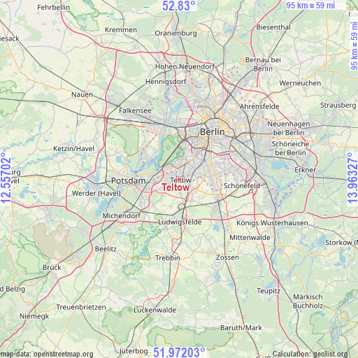
Teltow GPS coordinates[2]
52° 24' 11.16" North, 13° 15' 36.504" East
| Map corner | latitude | longitude |
|---|---|---|
| Upper-left | 52.83°, | 12.55702° |
| Center: | 52.4031°, | 13.26014° |
| Lower-right: | 51.97203°, | 13.96327° |
| Map W x H: | 95.4×95.4 km | = 59.3×59.3mi |
| max Lat: | 55.01917° ⇑23.8% North |
| Teltow: | 52.4031° |
| min Lat: | ⇓76.2% South 47.40724° |
| min Long | Teltow | max Long |
| 5.92978° | 13.26014° | 14.98853° |
| W 94%⇐ | ⇒6% E |
Elevation
Elevation of Teltow is 39 m = 128 ft, and this is 210.1 m = 689 ft below average elevation for this country.
| Max E: |
1256 m = 4121 ft | 83.2% |
| Avg. | 249.1 m = 817 ft | |
| Teltow | 39 m = 128 ft | |
Min E: |
-5 m = -16 ft | 16.8% |
See also: Germany elevation on elevation.city.
Geographical zone
Teltow is located in North temperate zone (between Tropic of Cancer and the Arctic Circle). Distance of this North polar circle is 1574.5 km =978.3 mi to North.| Distance of | km | miles | from Teltow |
|---|---|---|---|
| North Pole | 4180.4 | 2597.6 | to North |
| Arctic Circle | 1574.5 | 978.3 | to North |
| Tropic Cancer | 3220.8 | 2001.3 | to South |
| Equator | 5826.7 | 3620.5 | to South |


Nearby cities:
15 places around Teltow: (largest is in red/bold)
• Dahlem
6.4 km =4 mi,  16°
16°
• Friedenau
8.9 km =5.5 mi,  31°
31°
• Großbeeren
6 km =3.7 mi,  145°
145°
• Grunewald
8.9 km =5.5 mi,  2°
2°
• Kleinmachnow
2.4 km =1.5 mi,  282°
282°
• Lankwitz
6.9 km =4.3 mi,  57°
57°
• Lichterfelde
4.7 km =2.9 mi,  43°
43°
• Mariendorf
9.1 km =5.7 mi, 64°
• Marienfelde
7.5 km =4.7 mi,  76°
76°
• Nikolassee
5.3 km =3.3 mi,  310°
310°
• Schmargendorf
8.3 km =5.2 mi,  14°
14°
• Stahnsdorf
3.7 km =2.3 mi,  233°
233°
• Steglitz
7.6 km =4.7 mi, 39°
• Wannsee
7.3 km =4.5 mi, 284°
• Zehlendorf
3.4 km =2.1 mi,  348°
348°
Sources, notices
• [Note1] Compared only with cities in Germany existing in our database
• [Src1] Map data: © OpenStreetMap contributors (CC-BY-SA)
• [Src2] Other city data from geonames.org with taken over terms of usage.
• [Src3] Geographical zone / Annual Mean Temperature by Robert A. Rohde @ Wikipedia
