Grunewald geodata
Grunewald (Berlin) is a section of populated place; located in Germany in Europe/Berlin (GMT+2) time zone. With population of 11,631 people, there are 1412 cities with bigger population in this country. Compared to other cities in Germany, 77.3% of cities are located further ↓South; 94.1% of cities are located further ←West and 79.9% of cities have higher elevation than Grunewald. Note1


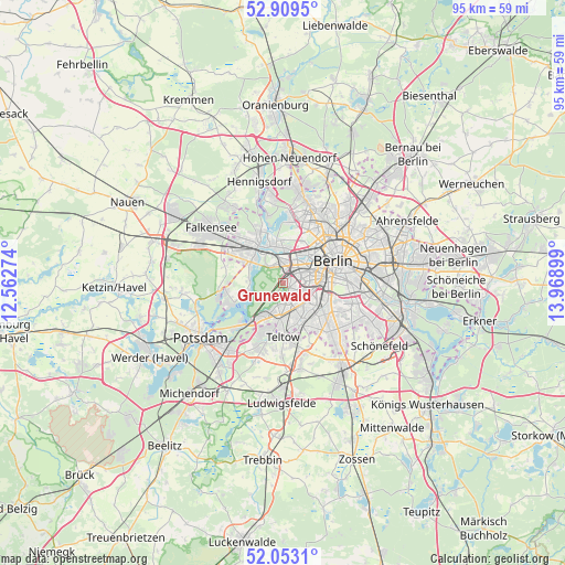
Grunewald GPS coordinates[2]
52° 29' 0.168" North, 13° 15' 57.096" East
| Map corner | latitude | longitude |
|---|---|---|
| Upper-left | 52.9095°, | 12.56274° |
| Center: | 52.48338°, | 13.26586° |
| Lower-right: | 52.0531°, | 13.96899° |
| Map W x H: | 95.2×95.2 km | = 59.2×59.2mi |
| max Lat: | 55.01917° ⇑22.7% North |
| Grunewald: | 52.48338° |
| min Lat: | ⇓77.3% South 47.40724° |
| min Long | Grunewald | max Long |
| 5.92978° | 13.26586° | 14.98853° |
| W 94.1%⇐ | ⇒5.9% E |
Elevation
Elevation of Grunewald is 47 m = 154 ft, and this is 202.1 m = 663 ft below average elevation for this country.
| Max E: |
1256 m = 4121 ft | 79.9% |
| Avg. | 249.1 m = 817 ft | |
| Grunewald | 47 m = 154 ft | |
Min E: |
-5 m = -16 ft | 20.1% |
See also: Germany elevation on elevation.city.
Geographical zone
Grunewald is located in North temperate zone (between Tropic of Cancer and the Arctic Circle). Distance of this North polar circle is 1565.6 km =972.8 mi to North.| Distance of | km | miles | from Grunewald |
|---|---|---|---|
| North Pole | 4171.5 | 2592 | to North |
| Arctic Circle | 1565.6 | 972.8 | to North |
| Tropic Cancer | 3229.7 | 2006.8 | to South |
| Equator | 5835.6 | 3626.1 | to South |


Nearby cities:
15 places around Grunewald: (largest is in red/bold)
• Charlottenburg
3.9 km =2.4 mi,  17°
17°
• Charlottenburg-Nord
5.6 km =3.5 mi, 19°
• Dahlem
3.2 km =2 mi,  152°
152°
• Friedenau
4.4 km =2.7 mi,  107°
107°
• Gatow
5.6 km =3.5 mi,  269°
269°
• Halensee
2.2 km =1.4 mi,  70°
70°
• Hansaviertel
6.5 km =4 mi,  52°
52°
• Lichterfelde
6.2 km =3.9 mi, 153°
• Schmargendorf
1.9 km =1.2 mi,  118°
118°
• Schöneberg
6 km =3.7 mi, 108°
• Siemensstadt
6.4 km =4 mi,  358°
358°
• Steglitz
5.4 km =3.4 mi, 124°
• Westend
3.8 km =2.4 mi,  10°
10°
• Wilmersdorf
3.4 km =2.1 mi,  90°
90°
• Zehlendorf
5.7 km =3.5 mi,  190°
190°
Sources, notices
• [Note1] Compared only with cities in Germany existing in our database
• [Src1] Map data: © OpenStreetMap contributors (CC-BY-SA)
• [Src2] Other city data from geonames.org with taken over terms of usage.
• [Src3] Geographical zone / Annual Mean Temperature by Robert A. Rohde @ Wikipedia
