Wagenfeld geodata
Wagenfeld (Lower Saxony) is a seat of a fourth-order administrative division; located in Germany in Europe/Berlin (GMT+2) time zone. With population of 7,132 people, there are 2153 cities with bigger population in this country. Compared to other cities in Germany, 78% of cities are located further ↓South; 70.3% of cities are located further →East and 82.8% of cities have higher elevation than Wagenfeld. Note1


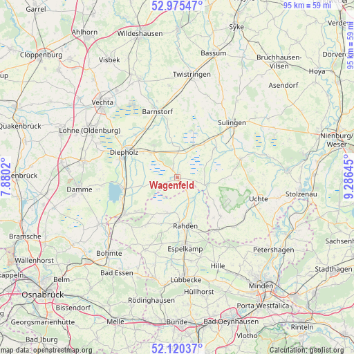
Wagenfeld GPS coordinates[2]
52° 33' 0" North, 8° 34' 59.988" East
| Map corner | latitude | longitude |
|---|---|---|
| Upper-left | 52.97547°, | 7.8802° |
| Center: | 52.55°, | 8.58333° |
| Lower-right: | 52.12037°, | 9.28645° |
| Map W x H: | 95.1×95.1 km | = 59.1×59.1mi |
| max Lat: | 55.01917° ⇑22% North |
| Wagenfeld: | 52.55° |
| min Lat: | ⇓78% South 47.40724° |
| min Long | Wagenfeld | max Long |
| 5.92978° | 8.58333° | 14.98853° |
| W 29.7%⇐ | ⇒70.3% E |
Elevation
Elevation of Wagenfeld is 40 m = 131 ft, and this is 209.1 m = 686 ft below average elevation for this country.
| Max E: |
1256 m = 4121 ft | 82.8% |
| Avg. | 249.1 m = 817 ft | |
| Wagenfeld | 40 m = 131 ft | |
Min E: |
-5 m = -16 ft | 17.2% |
See also: Germany elevation on elevation.city.
Geographical zone
Wagenfeld is located in North temperate zone (between Tropic of Cancer and the Arctic Circle). Distance of this North polar circle is 1558.2 km =968.2 mi to North.| Distance of | km | miles | from Wagenfeld |
|---|---|---|---|
| North Pole | 4164 | 2587.4 | to North |
| Arctic Circle | 1558.2 | 968.2 | to North |
| Tropic Cancer | 3237.1 | 2011.4 | to South |
| Equator | 5843 | 3630.7 | to South |


Nearby cities:
15 places around Wagenfeld: (largest is in red/bold)
• Bahrenborstel
15.4 km =9.6 mi,  81°
81°
• Barver
7.9 km =4.9 mi,  4°
4°
• Brockum
14.6 km =9.1 mi,  230°
230°
• Dickel
13 km =8.1 mi,  324°
324°
• Diepholz
15.8 km =9.8 mi,  294°
294°
• Eydelstedt
16 km =9.9 mi,  351°
351°
• Freistatt
9.4 km =5.8 mi,  29°
29°
• Hemsloh
7.5 km =4.7 mi, 318°
• Lembruch
15.9 km =9.9 mi,  263°
263°
• Quernheim
15.5 km =9.6 mi, 233°
• Rahden
13.1 km =8.1 mi,  171°
171°
• Rehden
9.6 km =6 mi,  314°
314°
• Varrel
12.9 km =8 mi,  51°
51°
• Wehrbleck
11.4 km =7.1 mi,  39°
39°
• Wetschen
11.5 km =7.1 mi, 307°
Sources, notices
• [Note1] Compared only with cities in Germany existing in our database
• [Src1] Map data: © OpenStreetMap contributors (CC-BY-SA)
• [Src2] Other city data from geonames.org with taken over terms of usage.
• [Src3] Geographical zone / Annual Mean Temperature by Robert A. Rohde @ Wikipedia
