Freistatt geodata
Freistatt (Lower Saxony) is a seat of a fourth-order administrative division; located in Germany in Europe/Berlin (GMT+2) time zone. With population of 905 people, there are 7509 cities with bigger population in this country. Compared to other cities in Germany, 79% of cities are located further ↓South; 69.5% of cities are located further →East and 82% of cities have higher elevation than Freistatt. Note1


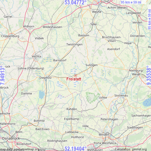
Freistatt GPS coordinates[2]
52° 37' 22.656" North, 8° 39' 8.1" East
| Map corner | latitude | longitude |
|---|---|---|
| Upper-left | 53.04772°, | 7.94913° |
| Center: | 52.62296°, | 8.65225° |
| Lower-right: | 52.19404°, | 9.35538° |
| Map W x H: | 94.9×94.9 km | = 59×59mi |
| max Lat: | 55.01917° ⇑21% North |
| Freistatt: | 52.62296° |
| min Lat: | ⇓79% South 47.40724° |
| min Long | Freistatt | max Long |
| 5.92978° | 8.65225° | 14.98853° |
| W 30.5%⇐ | ⇒69.5% E |
Elevation
Elevation of Freistatt is 42 m = 138 ft, and this is 207.1 m = 679 ft below average elevation for this country.
| Max E: |
1256 m = 4121 ft | 82% |
| Avg. | 249.1 m = 817 ft | |
| Freistatt | 42 m = 138 ft | |
Min E: |
-5 m = -16 ft | 18% |
See also: Germany elevation on elevation.city.
Geographical zone
Freistatt is located in North temperate zone (between Tropic of Cancer and the Arctic Circle). Distance of this North polar circle is 1550 km =963.1 mi to North.| Distance of | km | miles | from Freistatt |
|---|---|---|---|
| North Pole | 4155.9 | 2582.4 | to North |
| Arctic Circle | 1550 | 963.1 | to North |
| Tropic Cancer | 3245.2 | 2016.5 | to South |
| Equator | 5851.1 | 3635.7 | to South |


Nearby cities:
15 places around Freistatt: (largest is in red/bold)
• Bahrenborstel
12.1 km =7.5 mi,  119°
119°
• Barenburg
10 km =6.2 mi,  92°
92°
• Barnstorf
14 km =8.7 mi,  313°
313°
• Barver
4 km =2.5 mi,  266°
266°
• Dickel
12.4 km =7.7 mi,  281°
281°
• Ehrenburg
14.5 km =9 mi,  12°
12°
• Eydelstedt
10.5 km =6.5 mi,  317°
317°
• Hemsloh
10 km =6.2 mi,  255°
255°
• Kirchdorf
12.7 km =7.9 mi,  104°
104°
• Rehden
11.7 km =7.3 mi, 263°
• Sulingen
12.6 km =7.8 mi,  57°
57°
• Varrel
5.5 km =3.4 mi, 91°
• Wagenfeld
9.4 km =5.8 mi,  209°
209°
• Wehrbleck
2.6 km =1.6 mi,  75°
75°
• Wetschen
13.8 km =8.6 mi, 265°
Sources, notices
• [Note1] Compared only with cities in Germany existing in our database
• [Src1] Map data: © OpenStreetMap contributors (CC-BY-SA)
• [Src2] Other city data from geonames.org with taken over terms of usage.
• [Src3] Geographical zone / Annual Mean Temperature by Robert A. Rohde @ Wikipedia
