Bahrenborstel geodata
Bahrenborstel (Lower Saxony) is a seat of a fourth-order administrative division; located in Germany in Europe/Berlin (GMT+2) time zone. With population of 1,253 people, there are 6430 cities with bigger population in this country. Compared to other cities in Germany, 78.4% of cities are located further ↓South; 67.8% of cities are located further →East and 78.9% of cities have higher elevation than Bahrenborstel. Note1
Administrative division(s):
- Level 1: Lower Saxony
- Level 3: Landkreis Diepholz
- Level 4: Bahrenborstel


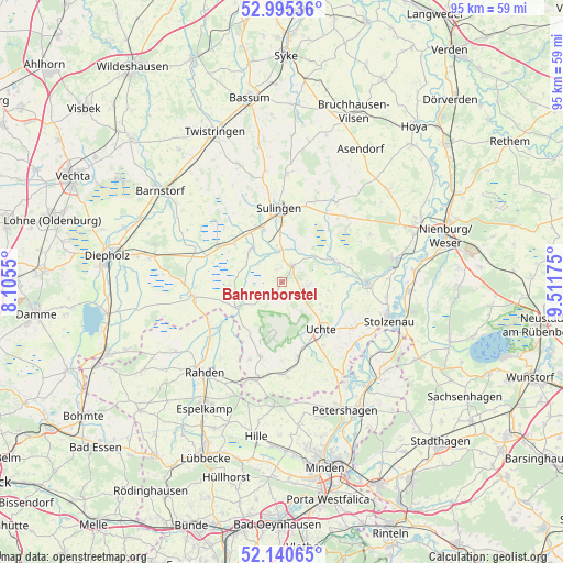
Bahrenborstel GPS coordinates[2]
52° 34' 12.324" North, 8° 48' 31.068" East
| Map corner | latitude | longitude |
|---|---|---|
| Upper-left | 52.99536°, | 8.1055° |
| Center: | 52.57009°, | 8.80863° |
| Lower-right: | 52.14065°, | 9.51175° |
| Map W x H: | 95×95 km | = 59×59mi |
| max Lat: | 55.01917° ⇑21.6% North |
| Bahrenborstel: | 52.57009° |
| min Lat: | ⇓78.4% South 47.40724° |
| min Long | Bahrenborstel | max Long |
| 5.92978° | 8.80863° | 14.98853° |
| W 32.2%⇐ | ⇒67.8% E |
Elevation
Elevation of Bahrenborstel is 50 m = 164 ft, and this is 199.1 m = 653 ft below average elevation for this country.
| Max E: |
1256 m = 4121 ft | 78.9% |
| Avg. | 249.1 m = 817 ft | |
| Bahrenborstel | 50 m = 164 ft | |
Min E: |
-5 m = -16 ft | 21.1% |
See also: Germany elevation on elevation.city.
Geographical zone
Bahrenborstel is located in North temperate zone (between Tropic of Cancer and the Arctic Circle). Distance of this North polar circle is 1555.9 km =966.8 mi to North.| Distance of | km | miles | from Bahrenborstel |
|---|---|---|---|
| North Pole | 4161.8 | 2586 | to North |
| Arctic Circle | 1555.9 | 966.8 | to North |
| Tropic Cancer | 3239.3 | 2012.8 | to South |
| Equator | 5845.2 | 3632 | to South |


Nearby cities:
15 places around Bahrenborstel: (largest is in red/bold)
• Barenburg
5.5 km =3.4 mi,  353°
353°
• Barver
15.6 km =9.7 mi,  291°
291°
• Borstel
15.5 km =9.6 mi,  44°
44°
• Freistatt
12.1 km =7.5 mi,  299°
299°
• Hassel
14.2 km =8.8 mi,  6°
6°
• Kirchdorf
3.3 km =2.1 mi,  32°
32°
• Maasen
14.5 km =9 mi,  20°
20°
• Mellinghausen
16.3 km =10.1 mi, 21°
• Steyerberg
14.6 km =9.1 mi,  89°
89°
• Sulingen
12.6 km =7.8 mi,  0°
0°
• Uchte
10.4 km =6.5 mi,  138°
138°
• Varrel
7.7 km =4.8 mi,  318°
318°
• Wagenfeld
15.4 km =9.6 mi,  261°
261°
• Warmsen
12.9 km =8 mi,  167°
167°
• Wehrbleck
10.3 km =6.4 mi,  309°
309°
Sources, notices
• [Note1] Compared only with cities in Germany existing in our database
• [Src1] Map data: © OpenStreetMap contributors (CC-BY-SA)
• [Src2] Other city data from geonames.org with taken over terms of usage.
• [Src3] Geographical zone / Annual Mean Temperature by Robert A. Rohde @ Wikipedia
