Eydelstedt geodata
Eydelstedt (Lower Saxony) is a seat of a fourth-order administrative division; located in Germany in Europe/Berlin (GMT+2) time zone. With population of 1,945 people, there are 5144 cities with bigger population in this country. Compared to other cities in Germany, 79.6% of cities are located further ↓South; 70.7% of cities are located further →East and 84.9% of cities have higher elevation than Eydelstedt. Note1


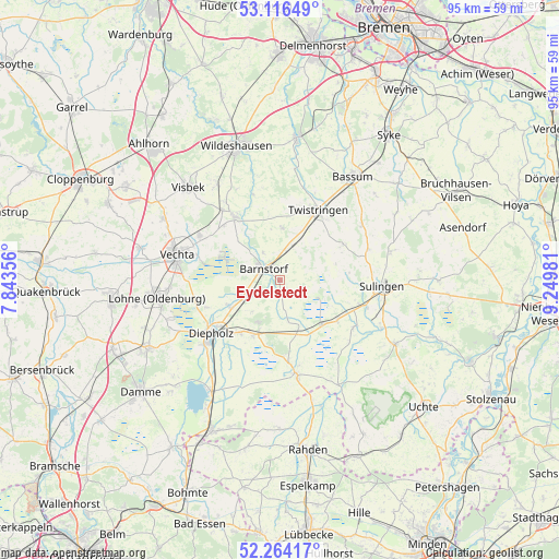
Eydelstedt GPS coordinates[2]
52° 41' 32.676" North, 8° 32' 48.048" East
| Map corner | latitude | longitude |
|---|---|---|
| Upper-left | 53.11649°, | 7.84356° |
| Center: | 52.69241°, | 8.54668° |
| Lower-right: | 52.26417°, | 9.24981° |
| Map W x H: | 94.8×94.8 km | = 58.9×58.9mi |
| max Lat: | 55.01917° ⇑20.4% North |
| Eydelstedt: | 52.69241° |
| min Lat: | ⇓79.6% South 47.40724° |
| min Long | Eydelstedt | max Long |
| 5.92978° | 8.54668° | 14.98853° |
| W 29.3%⇐ | ⇒70.7% E |
Elevation
Elevation of Eydelstedt is 35 m = 115 ft, and this is 214.1 m = 702 ft below average elevation for this country.
| Max E: |
1256 m = 4121 ft | 84.9% |
| Avg. | 249.1 m = 817 ft | |
| Eydelstedt | 35 m = 115 ft | |
Min E: |
-5 m = -16 ft | 15.1% |
See also: Germany elevation on elevation.city.
Geographical zone
Eydelstedt is located in North temperate zone (between Tropic of Cancer and the Arctic Circle). Distance of this North polar circle is 1542.3 km =958.3 mi to North.| Distance of | km | miles | from Eydelstedt |
|---|---|---|---|
| North Pole | 4148.2 | 2577.6 | to North |
| Arctic Circle | 1542.3 | 958.3 | to North |
| Tropic Cancer | 3252.9 | 2021.3 | to South |
| Equator | 5858.8 | 3640.5 | to South |


Nearby cities:
15 places around Eydelstedt: (largest is in red/bold)
• Barnstorf
3.6 km =2.2 mi,  303°
303°
• Barver
8.6 km =5.3 mi,  158°
158°
• Dickel
7.3 km =4.5 mi,  223°
223°
• Diepholz
15.2 km =9.4 mi,  231°
231°
• Drentwede
5.9 km =3.7 mi,  12°
12°
• Ehrenburg
12.1 km =7.5 mi,  58°
58°
• Freistatt
10.5 km =6.5 mi,  137°
137°
• Goldenstedt
13.2 km =8.2 mi,  324°
324°
• Hemsloh
10.5 km =6.5 mi,  193°
193°
• Rehden
10.2 km =6.3 mi,  205°
205°
• Scholen
15.5 km =9.6 mi,  72°
72°
• Twistringen
13.5 km =8.4 mi,  28°
28°
• Varrel
14.8 km =9.2 mi,  122°
122°
• Wehrbleck
12 km =7.5 mi,  126°
126°
• Wetschen
11 km =6.8 mi, 216°
Sources, notices
• [Note1] Compared only with cities in Germany existing in our database
• [Src1] Map data: © OpenStreetMap contributors (CC-BY-SA)
• [Src2] Other city data from geonames.org with taken over terms of usage.
• [Src3] Geographical zone / Annual Mean Temperature by Robert A. Rohde @ Wikipedia
