Wackerow geodata
Wackerow (Mecklenburg-Vorpommern) is a populated place; located in Germany in Europe/Berlin (GMT+2) time zone. With population of 1,445 people, there are 5987 cities with bigger population in this country. Compared to other cities in Germany, 88.2% of cities are located further ↓South; 92.2% of cities are located further ←West and 72.6% of cities have higher elevation than Wackerow. Note1
Administrative division(s):
- Level 1: Mecklenburg-Vorpommern
- Level 3: Mecklenburgische Seenplatte
- Level 4: Ritzerow


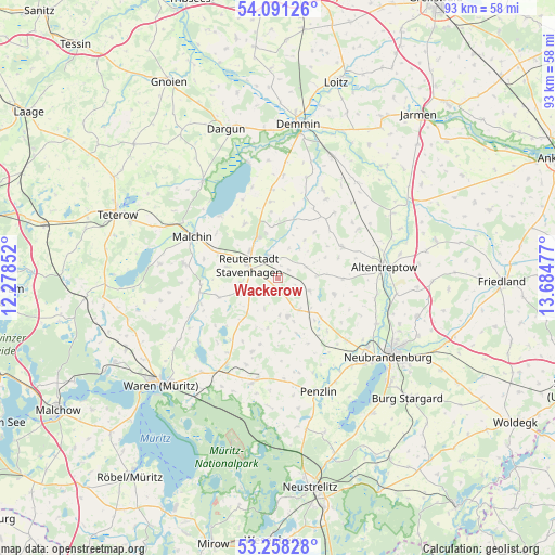
Wackerow GPS coordinates[2]
53° 40' 36.588" North, 12° 58' 53.904" East
| Map corner | latitude | longitude |
|---|---|---|
| Upper-left | 54.09126°, | 12.27852° |
| Center: | 53.67683°, | 12.98164° |
| Lower-right: | 53.25828°, | 13.68477° |
| Map W x H: | 92.6×92.6 km | = 57.5×57.5mi |
| max Lat: | 55.01917° ⇑11.8% North |
| Wackerow: | 53.67683° |
| min Lat: | ⇓88.2% South 47.40724° |
| min Long | Wackerow | max Long |
| 5.92978° | 12.98164° | 14.98853° |
| W 92.2%⇐ | ⇒7.8% E |
Elevation
Elevation of Wackerow is 74 m = 243 ft, and this is 175.1 m = 574 ft below average elevation for this country.
| Max E: |
1256 m = 4121 ft | 72.6% |
| Avg. | 249.1 m = 817 ft | |
| Wackerow | 74 m = 243 ft | |
Min E: |
-5 m = -16 ft | 27.4% |
See also: Germany elevation on elevation.city.
Geographical zone
Wackerow is located in North temperate zone (between Tropic of Cancer and the Arctic Circle). Distance of this North polar circle is 1432.9 km =890.4 mi to North.| Distance of | km | miles | from Wackerow |
|---|---|---|---|
| North Pole | 4038.8 | 2509.6 | to North |
| Arctic Circle | 1432.9 | 890.4 | to North |
| Tropic Cancer | 3362.4 | 2089.3 | to South |
| Equator | 5968.3 | 3708.5 | to South |


Nearby cities:
15 places around Wackerow: (largest is in red/bold)
• Blankenhof
14.8 km =9.2 mi,  138°
138°
• Breesen
13.2 km =8.2 mi,  113°
113°
• Faulenrost
13.6 km =8.5 mi,  251°
251°
• Gützkow
9.8 km =6.1 mi,  57°
57°
• Ivenack
3.9 km =2.4 mi,  347°
347°
• Jürgenstorf
5.3 km =3.3 mi, 250°
• Knorrendorf
7.5 km =4.7 mi,  132°
132°
• Kummerow
14 km =8.7 mi,  316°
316°
• Mölln
11.8 km =7.3 mi, 144°
• Reinberg
10.7 km =6.6 mi,  91°
91°
• Ritzerow
2.1 km =1.3 mi,  212°
212°
• Rosenow
6.4 km =4 mi, 144°
• Tützpatz
11.9 km =7.4 mi, 63°
• Wildberg
9.8 km =6.1 mi, 106°
• Wolde
6.7 km =4.2 mi, 86°
Sources, notices
• [Note1] Compared only with cities in Germany existing in our database
• [Src1] Map data: © OpenStreetMap contributors (CC-BY-SA)
• [Src2] Other city data from geonames.org with taken over terms of usage.
• [Src3] Geographical zone / Annual Mean Temperature by Robert A. Rohde @ Wikipedia
