Ivenack geodata
Ivenack (Mecklenburg-Vorpommern) is a populated place; located in Germany in Europe/Berlin (GMT+2) time zone. With population of 965 people, there are 7293 cities with bigger population in this country. Compared to other cities in Germany, 88.8% of cities are located further ↓South; 92.1% of cities are located further ←West and 78.7% of cities have higher elevation than Ivenack. Note1
Administrative division(s):
- Level 1: Mecklenburg-Vorpommern
- Level 3: Mecklenburgische Seenplatte
- Level 4: Ivenack


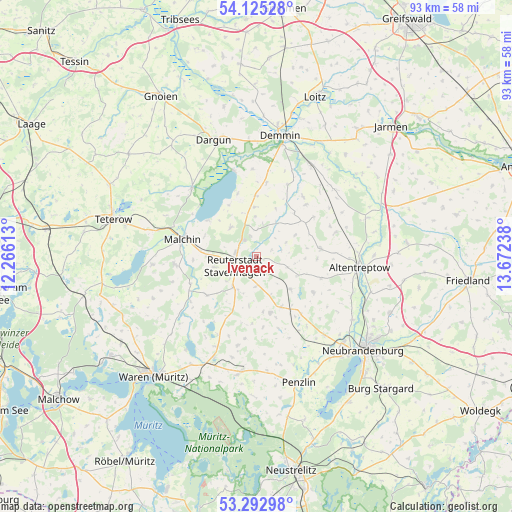
Ivenack GPS coordinates[2]
53° 42' 40.284" North, 12° 58' 9.3" East
| Map corner | latitude | longitude |
|---|---|---|
| Upper-left | 54.12528°, | 12.26613° |
| Center: | 53.71119°, | 12.96925° |
| Lower-right: | 53.29298°, | 13.67238° |
| Map W x H: | 92.5×92.5 km | = 57.5×57.5mi |
| max Lat: | 55.01917° ⇑11.2% North |
| Ivenack: | 53.71119° |
| min Lat: | ⇓88.8% South 47.40724° |
| min Long | Ivenack | max Long |
| 5.92978° | 12.96925° | 14.98853° |
| W 92.1%⇐ | ⇒7.9% E |
Elevation
Elevation of Ivenack is 51 m = 167 ft, and this is 198.1 m = 650 ft below average elevation for this country.
| Max E: |
1256 m = 4121 ft | 78.7% |
| Avg. | 249.1 m = 817 ft | |
| Ivenack | 51 m = 167 ft | |
Min E: |
-5 m = -16 ft | 21.3% |
See also: Germany elevation on elevation.city.
Geographical zone
Ivenack is located in North temperate zone (between Tropic of Cancer and the Arctic Circle). Distance of this North polar circle is 1429 km =887.9 mi to North.| Distance of | km | miles | from Ivenack |
|---|---|---|---|
| North Pole | 4034.9 | 2507.2 | to North |
| Arctic Circle | 1429 | 887.9 | to North |
| Tropic Cancer | 3366.2 | 2091.7 | to South |
| Equator | 5972.1 | 3710.9 | to South |


Nearby cities:
15 places around Ivenack: (largest is in red/bold)
• Beggerow
14.1 km =8.8 mi,  23°
23°
• Borrentin
11 km =6.8 mi,  359°
359°
• Gützkow
9.2 km =5.7 mi,  80°
80°
• Jürgenstorf
7 km =4.3 mi,  216°
216°
• Knorrendorf
10.9 km =6.8 mi,  144°
144°
• Kummerow
10.9 km =6.8 mi,  305°
305°
• Malchin
13.8 km =8.6 mi,  283°
283°
• Reinberg
12.2 km =7.6 mi,  109°
109°
• Ritzerow
5.6 km =3.5 mi,  183°
183°
• Rosenow
10.1 km =6.3 mi,  153°
153°
• Sarow
12.6 km =7.8 mi,  43°
43°
• Tützpatz
11.6 km =7.2 mi, 82°
• Wackerow
3.9 km =2.4 mi,  167°
167°
• Wildberg
12.1 km =7.5 mi,  122°
122°
• Wolde
8.2 km =5.1 mi, 114°
Sources, notices
• [Note1] Compared only with cities in Germany existing in our database
• [Src1] Map data: © OpenStreetMap contributors (CC-BY-SA)
• [Src2] Other city data from geonames.org with taken over terms of usage.
• [Src3] Geographical zone / Annual Mean Temperature by Robert A. Rohde @ Wikipedia
