Faulenrost geodata
Faulenrost (Mecklenburg-Vorpommern) is a populated place; located in Germany in Europe/Berlin (GMT+2) time zone. With population of 761 people, there are 8043 cities with bigger population in this country. Compared to other cities in Germany, 87.6% of cities are located further ↓South; 90.6% of cities are located further ←West and 84.9% of cities have higher elevation than Faulenrost. Note1
Administrative division(s):
- Level 1: Mecklenburg-Vorpommern
- Level 3: Mecklenburgische Seenplatte
- Level 4: Faulenrost


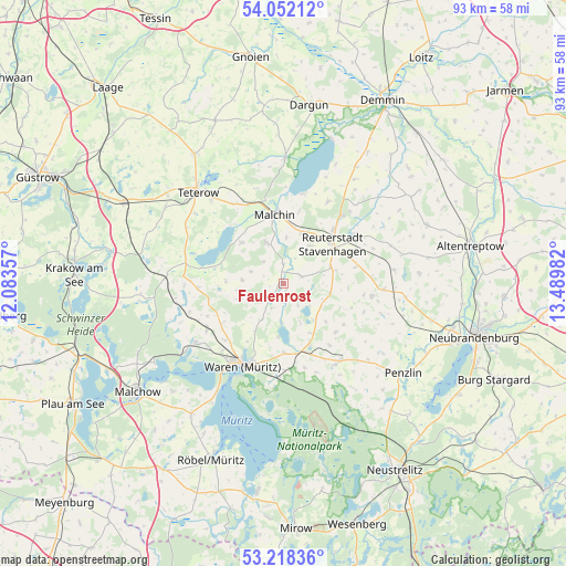
Faulenrost GPS coordinates[2]
53° 38' 14.28" North, 12° 47' 12.084" East
| Map corner | latitude | longitude |
|---|---|---|
| Upper-left | 54.05212°, | 12.08357° |
| Center: | 53.6373°, | 12.78669° |
| Lower-right: | 53.21836°, | 13.48982° |
| Map W x H: | 92.7×92.7 km | = 57.6×57.6mi |
| max Lat: | 55.01917° ⇑12.4% North |
| Faulenrost: | 53.6373° |
| min Lat: | ⇓87.6% South 47.40724° |
| min Long | Faulenrost | max Long |
| 5.92978° | 12.78669° | 14.98853° |
| W 90.6%⇐ | ⇒9.4% E |
Elevation
Elevation of Faulenrost is 35 m = 115 ft, and this is 214.1 m = 702 ft below average elevation for this country.
| Max E: |
1256 m = 4121 ft | 84.9% |
| Avg. | 249.1 m = 817 ft | |
| Faulenrost | 35 m = 115 ft | |
Min E: |
-5 m = -16 ft | 15.1% |
See also: Germany elevation on elevation.city.
Geographical zone
Faulenrost is located in North temperate zone (between Tropic of Cancer and the Arctic Circle). Distance of this North polar circle is 1437.3 km =893.1 mi to North.| Distance of | km | miles | from Faulenrost |
|---|---|---|---|
| North Pole | 4043.2 | 2512.3 | to North |
| Arctic Circle | 1437.3 | 893.1 | to North |
| Tropic Cancer | 3358 | 2086.6 | to South |
| Equator | 5963.9 | 3705.8 | to South |


Nearby cities:
15 places around Faulenrost: (largest is in red/bold)
• Basedow
9.7 km =6 mi,  313°
313°
• Dahmen
13.8 km =8.6 mi,  280°
280°
• Gielow
7.2 km =4.5 mi,  337°
337°
• Grabowhöfe
14.8 km =9.2 mi,  238°
238°
• Groß Gievitz
6.3 km =3.9 mi,  182°
182°
• Groß Plasten
11 km =6.8 mi,  157°
157°
• Ivenack
14.6 km =9.1 mi,  55°
55°
• Jürgenstorf
8.2 km =5.1 mi,  71°
71°
• Kargow
14.1 km =8.8 mi, 180°
• Malchin
11.5 km =7.1 mi,  352°
352°
• Remplin
14.2 km =8.8 mi, 335°
• Ritzerow
12 km =7.5 mi,  77°
77°
• Vielist
13.5 km =8.4 mi,  226°
226°
• Wackerow
13.6 km =8.5 mi, 71°
• Waren
14.8 km =9.2 mi,  208°
208°
Sources, notices
• [Note1] Compared only with cities in Germany existing in our database
• [Src1] Map data: © OpenStreetMap contributors (CC-BY-SA)
• [Src2] Other city data from geonames.org with taken over terms of usage.
• [Src3] Geographical zone / Annual Mean Temperature by Robert A. Rohde @ Wikipedia
