Ürzig geodata
Ürzig (Rheinland-Pfalz) is a seat of a fourth-order administrative division; located in Germany in Europe/Berlin (GMT+2) time zone. With population of 914 people, there are 7476 cities with bigger population in this country. Compared to other cities in Germany, 64.3% of cities are located further ↑North; 93.3% of cities are located further →East and 65.4% of cities have higher elevation than Ürzig. Note1
Administrative division(s):
- Level 1: Rheinland-Pfalz
- Level 3: Landkreis Bernkastel-Wittlich
- Level 4: Ürzig


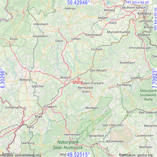
Ürzig GPS coordinates[2]
49° 58' 45.948" North, 7° 0' 21.96" East
| Map corner | latitude | longitude |
|---|---|---|
| Upper-left | 50.42946°, | 6.30298° |
| Center: | 49.97943°, | 7.0061° |
| Lower-right: | 49.52515°, | 7.70923° |
| Map W x H: | 100.5×100.5 km | = 62.4×62.4mi |
| max Lat: | 55.01917° ⇑64.3% North |
| Ürzig: | 49.97943° |
| min Lat: | ⇓35.7% South 47.40724° |
| min Long | Ürzig | max Long |
| 5.92978° | 7.0061° | 14.98853° |
| W 6.7%⇐ | ⇒93.3% E |
Elevation
Elevation of Ürzig is 118 m = 387 ft, and this is 131.1 m = 430 ft below average elevation for this country.
| Max E: |
1256 m = 4121 ft | 65.4% |
| Avg. | 249.1 m = 817 ft | |
| Ürzig | 118 m = 387 ft | |
Min E: |
-5 m = -16 ft | 34.6% |
See also: Germany elevation on elevation.city.
Geographical zone
Ürzig is located in North temperate zone (between Tropic of Cancer and the Arctic Circle). Distance of this North polar circle is 1844 km =1145.8 mi to North.| Distance of | km | miles | from Ürzig |
|---|---|---|---|
| North Pole | 4449.9 | 2765 | to North |
| Arctic Circle | 1844 | 1145.8 | to North |
| Tropic Cancer | 2951.3 | 1833.9 | to South |
| Equator | 5557.2 | 3453.1 | to South |


Nearby cities:
15 places around Ürzig: (largest is in red/bold)
• Altrich
7.2 km =4.5 mi,  249°
249°
• Bausendorf
4.2 km =2.6 mi,  353°
353°
• Bengel
6 km =3.7 mi,  46°
46°
• Erden
0.9 km =0.6 mi,  60°
60°
• Flußbach
6.6 km =4.1 mi,  308°
308°
• Graach
6.5 km =4 mi,  140°
140°
• Kinderbeuern
3.6 km =2.2 mi,  20°
20°
• Kinheim
3.4 km =2.1 mi,  114°
114°
• Kröv
5.5 km =3.4 mi,  85°
85°
• Lieser
7 km =4.3 mi,  173°
173°
• Lösnich
2.7 km =1.7 mi,  101°
101°
• Maring-Noviand
5.1 km =3.2 mi,  184°
184°
• Neuerburg
4.8 km =3 mi,  300°
300°
• Platten
4.9 km =3 mi,  230°
230°
• Zeltingen-Rachtig
3.4 km =2.1 mi, 166°
Sources, notices
• [Note1] Compared only with cities in Germany existing in our database
• [Src1] Map data: © OpenStreetMap contributors (CC-BY-SA)
• [Src2] Other city data from geonames.org with taken over terms of usage.
• [Src3] Geographical zone / Annual Mean Temperature by Robert A. Rohde @ Wikipedia
