Zeltingen-Rachtig geodata
Zeltingen-Rachtig (Rheinland-Pfalz) is a seat of a fourth-order administrative division; located in Germany in Europe/Berlin (GMT+2) time zone. With population of 2,321 people, there are 4646 cities with bigger population in this country. Compared to other cities in Germany, 65.2% of cities are located further ↑North; 93.2% of cities are located further →East and 67.3% of cities have higher elevation than Zeltingen-Rachtig. Note1
Administrative division(s):
- Level 1: Rheinland-Pfalz
- Level 3: Landkreis Bernkastel-Wittlich
- Level 4: Zeltingen-Rachtig


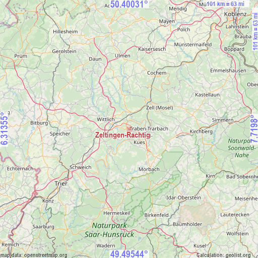
Zeltingen-Rachtig GPS coordinates[2]
49° 57' 0" North, 7° 1' 0.012" East
| Map corner | latitude | longitude |
|---|---|---|
| Upper-left | 50.40031°, | 6.31355° |
| Center: | 49.95°, | 7.01667° |
| Lower-right: | 49.49544°, | 7.7198° |
| Map W x H: | 100.6×100.6 km | = 62.5×62.5mi |
| max Lat: | 55.01917° ⇑65.2% North |
| Zeltingen-Rachtig: | 49.95° |
| min Lat: | ⇓34.8% South 47.40724° |
| min Long | Zeltingen-Racht | max Long |
| 5.92978° | 7.01667° | 14.98853° |
| W 6.8%⇐ | ⇒93.2% E |
Elevation
Elevation of Zeltingen-Rachtig is 106 m = 348 ft, and this is 143.1 m = 469 ft below average elevation for this country.
| Max E: |
1256 m = 4121 ft | 67.3% |
| Avg. | 249.1 m = 817 ft | |
| Zeltingen-Rachtig | 106 m = 348 ft | |
Min E: |
-5 m = -16 ft | 32.7% |
See also: Germany elevation on elevation.city.
Geographical zone
Zeltingen-Rachtig is located in North temperate zone (between Tropic of Cancer and the Arctic Circle). Distance of this North polar circle is 1847.3 km =1147.9 mi to North.| Distance of | km | miles | from Zeltingen-Rachtig |
|---|---|---|---|
| North Pole | 4453.1 | 2767 | to North |
| Arctic Circle | 1847.3 | 1147.9 | to North |
| Tropic Cancer | 2948 | 1831.8 | to South |
| Equator | 5553.9 | 3451 | to South |


Nearby cities:
15 places around Zeltingen-Rachtig: (largest is in red/bold)
• Bernkastel-Kues
5.7 km =3.5 mi,  131°
131°
• Brauneberg
5.5 km =3.4 mi,  207°
207°
• Erden
3.7 km =2.3 mi,  0°
0°
• Graach
3.8 km =2.4 mi,  117°
117°
• Kinderbeuern
6.6 km =4.1 mi, 4°
• Kinheim
3 km =1.9 mi,  52°
52°
• Kröv
6 km =3.7 mi, 52°
• Lieser
3.7 km =2.3 mi,  180°
180°
• Lösnich
3.3 km =2.1 mi,  34°
34°
• Maring-Noviand
2.2 km =1.4 mi, 212°
• Mülheim
4.2 km =2.6 mi, 177°
• Osann-Monzel
6 km =3.7 mi,  232°
232°
• Platten
4.5 km =2.8 mi,  272°
272°
• Veldenz
6.8 km =4.2 mi, 176°
• Ürzig
3.4 km =2.1 mi,  346°
346°
Sources, notices
• [Note1] Compared only with cities in Germany existing in our database
• [Src1] Map data: © OpenStreetMap contributors (CC-BY-SA)
• [Src2] Other city data from geonames.org with taken over terms of usage.
• [Src3] Geographical zone / Annual Mean Temperature by Robert A. Rohde @ Wikipedia
