Kröv geodata
Kröv (Rheinland-Pfalz) is a seat of a fourth-order administrative division; located in Germany in Europe/Berlin (GMT+2) time zone. With population of 2,318 people, there are 4649 cities with bigger population in this country. Compared to other cities in Germany, 64.2% of cities are located further ↑North; 92.5% of cities are located further →East and 56.7% of cities have higher elevation than Kröv. Note1
Administrative division(s):
- Level 1: Rheinland-Pfalz
- Level 3: Landkreis Bernkastel-Wittlich
- Level 4: Kröv


Kröv GPS coordinates[2]
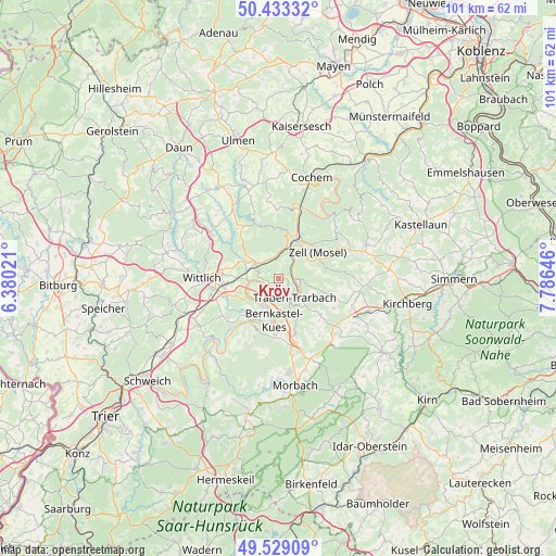
49° 58' 59.988" North, 7° 4' 59.988" East
| Map corner | latitude | longitude |
|---|---|---|
| Upper-left | 50.43332°, | 6.38021° |
| Center: | 49.98333°, | 7.08333° |
| Lower-right: | 49.52909°, | 7.78646° |
| Map W x H: | 100.5×100.5 km | = 62.4×62.4mi |
| max Lat: | 55.01917° ⇑64.2% North |
| Kröv: | 49.98333° |
| min Lat: | ⇓35.8% South 47.40724° |
| min Long | Kröv | max Long |
| 5.92978° | 7.08333° | 14.98853° |
| W 7.5%⇐ | ⇒92.5% E |
Elevation
Elevation of Kröv is 177 m = 581 ft, and this is 72.1 m = 237 ft below average elevation for this country.
| Max E: |
1256 m = 4121 ft | 56.7% |
| Avg. | 249.1 m = 817 ft | |
| Kröv | 177 m = 581 ft | |
Min E: |
-5 m = -16 ft | 43.3% |
See also: Germany elevation on elevation.city.
Geographical zone
Kröv is located in North temperate zone (between Tropic of Cancer and the Arctic Circle). Distance of this North polar circle is 1843.5 km =1145.5 mi to North.| Distance of | km | miles | from Kröv |
|---|---|---|---|
| North Pole | 4449.4 | 2764.7 | to North |
| Arctic Circle | 1843.5 | 1145.5 | to North |
| Tropic Cancer | 2951.7 | 1834.1 | to South |
| Equator | 5557.6 | 3453.3 | to South |


Nearby cities:
15 places around Kröv: (largest is in red/bold)
• Bausendorf
7 km =4.3 mi,  301°
301°
• Bengel
3.9 km =2.4 mi,  342°
342°
• Briedel
6 km =3.7 mi,  52°
52°
• Enkirch
3.3 km =2.1 mi,  88°
88°
• Erden
4.8 km =3 mi,  270°
270°
• Graach
5.6 km =3.5 mi,  194°
194°
• Kinderbeuern
5.2 km =3.2 mi, 304°
• Kinheim
3 km =1.9 mi,  232°
232°
• Lösnich
3 km =1.9 mi,  251°
251°
• Pünderich
7.1 km =4.4 mi,  26°
26°
• Reil
4.4 km =2.7 mi, 32°
• Starkenburg
4 km =2.5 mi,  117°
117°
• Traben-Trarbach
4.3 km =2.7 mi,  147°
147°
• Zeltingen-Rachtig
6 km =3.7 mi, 232°
• Ürzig
5.5 km =3.4 mi, 265°
Sources, notices
• [Note1] Compared only with cities in Germany existing in our database
• [Src1] Map data: © OpenStreetMap contributors (CC-BY-SA)
• [Src2] Other city data from geonames.org with taken over terms of usage.
• [Src3] Geographical zone / Annual Mean Temperature by Robert A. Rohde @ Wikipedia
