Dettingen geodata
Dettingen (Baden-Württemberg) is a populated place; located in Germany in Europe/Berlin (GMT+2) time zone. With population of 2,240 people, there are 4760 cities with bigger population in this country. Compared to other cities in Germany, 91.7% of cities are located further ↑North; 54% of cities are located further →East and 88.9% of cities have lower elevation than Dettingen. Note1
Administrative division(s):
- Level 1: Baden-Württemberg
- Level 2: Tübingen Region
- Level 3: Alb-Donau-Kreis
- Level 4: Ehingen (Donau)


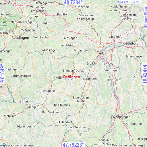
Dettingen GPS coordinates[2]
48° 15' 44.856" North, 9° 43' 17.796" East
| Map corner | latitude | longitude |
|---|---|---|
| Upper-left | 48.7284°, | 9.01849° |
| Center: | 48.26246°, | 9.72161° |
| Lower-right: | 47.79223°, | 10.42474° |
| Map W x H: | 104.1×104.1 km | = 64.7×64.7mi |
| max Lat: | 55.01917° ⇑91.7% North |
| Dettingen: | 48.26246° |
| min Lat: | ⇓8.3% South 47.40724° |
| min Long | Dettingen | max Long |
| 5.92978° | 9.72161° | 14.98853° |
| W 46%⇐ | ⇒54% E |
Elevation
Elevation of Dettingen is 503 m = 1650 ft, and this is 253.9 m = 833 ft above average elevation for this country.
| Max E: |
1256 m = 4121 ft | 11.1% |
| Dettingen | 503 m 1650 ft | |
| Avg. | 249.1 m = 817 ft | |
Min E: |
-5 m = -16 ft | 88.9% |
See also: Germany elevation on elevation.city.
Geographical zone
Dettingen is located in North temperate zone (between Tropic of Cancer and the Arctic Circle). Distance of this North polar circle is 2034.9 km =1264.4 mi to North.| Distance of | km | miles | from Dettingen |
|---|---|---|---|
| North Pole | 4640.8 | 2883.7 | to North |
| Arctic Circle | 2034.9 | 1264.4 | to North |
| Tropic Cancer | 2760.4 | 1715.2 | to South |
| Equator | 5366.3 | 3334.5 | to South |


Nearby cities:
15 places around Dettingen: (largest is in red/bold)
• Allmendingen
7.6 km =4.7 mi,  1°
1°
• Altheim
8.1 km =5 mi,  26°
26°
• Ehingen
2.3 km =1.4 mi,  11°
11°
• Emerkingen
7.4 km =4.6 mi,  220°
220°
• Ersingen
10.4 km =6.5 mi,  71°
71°
• Griesingen
4.6 km =2.9 mi,  84°
84°
• Hausen am Bussen
9.1 km =5.7 mi,  231°
231°
• Munderkingen
6.5 km =4 mi,  242°
242°
• Oberdischingen
9.3 km =5.8 mi,  63°
63°
• Oberstadion
8.8 km =5.5 mi,  194°
194°
• Rottenacker
3.9 km =2.4 mi, 217°
• Untermarchtal
8.7 km =5.4 mi,  252°
252°
• Unterstadion
7 km =4.3 mi,  200°
200°
• Unterwachingen
8.8 km =5.5 mi, 221°
• Öpfingen
6.6 km =4.1 mi, 66°
Sources, notices
• [Note1] Compared only with cities in Germany existing in our database
• [Src1] Map data: © OpenStreetMap contributors (CC-BY-SA)
• [Src2] Other city data from geonames.org with taken over terms of usage.
• [Src3] Geographical zone / Annual Mean Temperature by Robert A. Rohde @ Wikipedia
