Oberstadion geodata
Oberstadion (Baden-Württemberg) is a seat of a fourth-order administrative division; located in Germany in Europe/Berlin (GMT+2) time zone. With population of 1,577 people, there are 5728 cities with bigger population in this country. Compared to other cities in Germany, 92.8% of cities are located further ↑North; 54.5% of cities are located further →East and 90.8% of cities have lower elevation than Oberstadion. Note1
Administrative division(s):
- Level 1: Baden-Württemberg
- Level 2: Tübingen Region
- Level 3: Alb-Donau-Kreis
- Level 4: Oberstadion


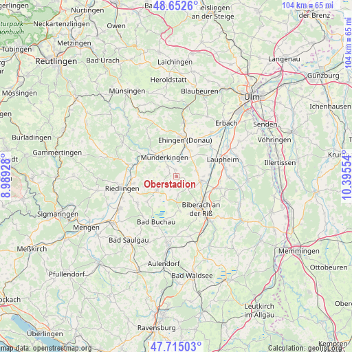
Oberstadion GPS coordinates[2]
48° 11' 9.456" North, 9° 41' 32.676" East
| Map corner | latitude | longitude |
|---|---|---|
| Upper-left | 48.6526°, | 8.98928° |
| Center: | 48.18596°, | 9.69241° |
| Lower-right: | 47.71503°, | 10.39554° |
| Map W x H: | 104.2×104.2 km | = 64.7×64.7mi |
| max Lat: | 55.01917° ⇑92.8% North |
| Oberstadion: | 48.18596° |
| min Lat: | ⇓7.2% South 47.40724° |
| min Long | Oberstadion | max Long |
| 5.92978° | 9.69241° | 14.98853° |
| W 45.5%⇐ | ⇒54.5% E |
Elevation
Elevation of Oberstadion is 525 m = 1722 ft, and this is 275.9 m = 905 ft above average elevation for this country.
| Max E: |
1256 m = 4121 ft | 9.2% |
| Oberstadion | 525 m 1722 ft | |
| Avg. | 249.1 m = 817 ft | |
Min E: |
-5 m = -16 ft | 90.8% |
See also: Germany elevation on elevation.city.
Geographical zone
Oberstadion is located in North temperate zone (between Tropic of Cancer and the Arctic Circle). Distance of this North polar circle is 2043.4 km =1269.7 mi to North.| Distance of | km | miles | from Oberstadion |
|---|---|---|---|
| North Pole | 4649.3 | 2888.9 | to North |
| Arctic Circle | 2043.4 | 1269.7 | to North |
| Tropic Cancer | 2751.9 | 1710 | to South |
| Equator | 5357.8 | 3329.2 | to South |


Nearby cities:
15 places around Oberstadion: (largest is in red/bold)
• Alleshausen
10.6 km =6.6 mi,  209°
209°
• Attenweiler
5.9 km =3.7 mi,  174°
174°
• Dettingen
8.8 km =5.5 mi,  14°
14°
• Emerkingen
3.9 km =2.4 mi,  317°
317°
• Grundsheim
2.9 km =1.8 mi,  221°
221°
• Hausen am Bussen
5.8 km =3.6 mi,  300°
300°
• Munderkingen
6.6 km =4.1 mi,  327°
327°
• Obermarchtal
10.3 km =6.4 mi, 300°
• Rottenacker
5.4 km =3.4 mi,  357°
357°
• Seekirch
10.1 km =6.3 mi,  198°
198°
• Untermarchtal
8.5 km =5.3 mi,  314°
314°
• Unterstadion
1.9 km =1.2 mi,  351°
351°
• Unterwachingen
4.1 km =2.5 mi, 297°
• Uttenweiler
6.9 km =4.3 mi,  234°
234°
• Warthausen
10.1 km =6.3 mi,  129°
129°
Sources, notices
• [Note1] Compared only with cities in Germany existing in our database
• [Src1] Map data: © OpenStreetMap contributors (CC-BY-SA)
• [Src2] Other city data from geonames.org with taken over terms of usage.
• [Src3] Geographical zone / Annual Mean Temperature by Robert A. Rohde @ Wikipedia
