Unterhausen geodata
Unterhausen (Baden-Württemberg) is a populated place; located in Germany in Europe/Berlin (GMT+2) time zone. With population of 9,030 people, there are 1781 cities with bigger population in this country. Compared to other cities in Germany, 89.9% of cities are located further ↑North; 61.4% of cities are located further →East and 89.6% of cities have lower elevation than Unterhausen. Note1
Administrative division(s):
- Level 1: Baden-Württemberg
- Level 2: Tübingen Region
- Level 3: Landkreis Reutlingen
- Level 4: Lichtenstein


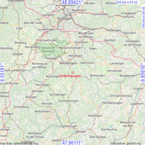
Unterhausen GPS coordinates[2]
48° 25' 47.28" North, 9° 15' 18.144" East
| Map corner | latitude | longitude |
|---|---|---|
| Upper-left | 48.89421°, | 8.55191° |
| Center: | 48.4298°, | 9.25504° |
| Lower-right: | 47.96111°, | 9.95816° |
| Map W x H: | 103.8×103.7 km | = 64.5×64.4mi |
| max Lat: | 55.01917° ⇑89.9% North |
| Unterhausen: | 48.4298° |
| min Lat: | ⇓10.1% South 47.40724° |
| min Long | Unterhausen | max Long |
| 5.92978° | 9.25504° | 14.98853° |
| W 38.6%⇐ | ⇒61.4% E |
Elevation
Elevation of Unterhausen is 509 m = 1670 ft, and this is 259.9 m = 853 ft above average elevation for this country.
| Max E: |
1256 m = 4121 ft | 10.4% |
| Unterhausen | 509 m 1670 ft | |
| Avg. | 249.1 m = 817 ft | |
Min E: |
-5 m = -16 ft | 89.6% |
See also: Germany elevation on elevation.city.
Geographical zone
Unterhausen is located in North temperate zone (between Tropic of Cancer and the Arctic Circle). Distance of this North polar circle is 2016.3 km =1252.9 mi to North.| Distance of | km | miles | from Unterhausen |
|---|---|---|---|
| North Pole | 4622.2 | 2872.1 | to North |
| Arctic Circle | 2016.3 | 1252.9 | to North |
| Tropic Cancer | 2779 | 1726.8 | to South |
| Equator | 5384.9 | 3346 | to South |


Nearby cities:
15 places around Unterhausen: (largest is in red/bold)
• Bad Urach
12.7 km =7.9 mi,  57°
57°
• Dettingen an der Erms
13 km =8.1 mi,  30°
30°
• Eningen unter Achalm
6.4 km =4 mi,  2°
2°
• Gomadingen
10.5 km =6.5 mi,  108°
108°
• Gomaringen
12 km =7.5 mi,  282°
282°
• Kirchentellinsfurt
14 km =8.7 mi,  325°
325°
• Kusterdingen
14.4 km =8.9 mi,  316°
316°
• Metzingen
12.1 km =7.5 mi,  9°
9°
• Nehren
13.7 km =8.5 mi,  270°
270°
• Pfullingen
4.4 km =2.7 mi, 332°
• Reutlingen
7.8 km =4.8 mi, 331°
• Sankt Johann
7.1 km =4.4 mi,  67°
67°
• Sickenhausen
12.7 km =7.9 mi, 334°
• Trochtelfingen
13.5 km =8.4 mi,  183°
183°
• Wannweil
12.4 km =7.7 mi, 321°
Sources, notices
• [Note1] Compared only with cities in Germany existing in our database
• [Src1] Map data: © OpenStreetMap contributors (CC-BY-SA)
• [Src2] Other city data from geonames.org with taken over terms of usage.
• [Src3] Geographical zone / Annual Mean Temperature by Robert A. Rohde @ Wikipedia
