Kirchentellinsfurt geodata
Kirchentellinsfurt (Baden-Württemberg) is a seat of a fourth-order administrative division; located in Germany in Europe/Berlin (GMT+2) time zone. With population of 5,406 people, there are 2664 cities with bigger population in this country. Compared to other cities in Germany, 88.7% of cities are located further ↑North; 63.3% of cities are located further →East and 71.1% of cities have lower elevation than Kirchentellinsfurt. Note1
Administrative division(s):
- Level 1: Baden-Württemberg
- Level 2: Tübingen Region
- Level 3: Landkreis Tübingen
- Level 4: Kirchentellinsfurt


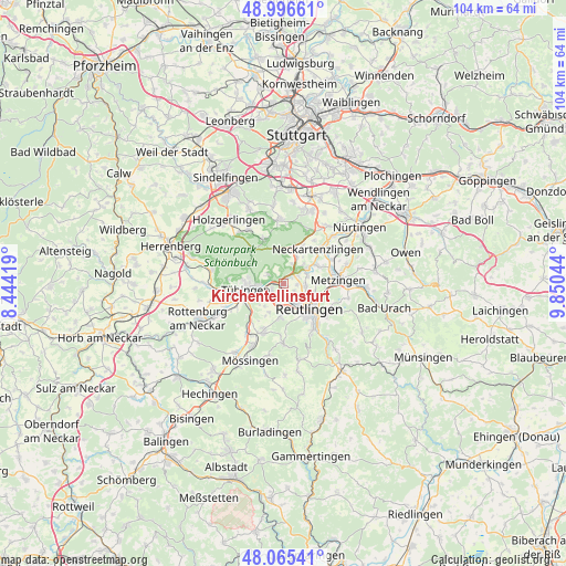
Kirchentellinsfurt GPS coordinates[2]
48° 31' 59.34" North, 9° 8' 50.352" East
| Map corner | latitude | longitude |
|---|---|---|
| Upper-left | 48.99661°, | 8.44419° |
| Center: | 48.53315°, | 9.14732° |
| Lower-right: | 48.06541°, | 9.85044° |
| Map W x H: | 103.5×103.5 km | = 64.3×64.3mi |
| max Lat: | 55.01917° ⇑88.7% North |
| Kirchentellinsfurt: | 48.53315° |
| min Lat: | ⇓11.3% South 47.40724° |
| min Long | Kirchentellinsf | max Long |
| 5.92978° | 9.14732° | 14.98853° |
| W 36.7%⇐ | ⇒63.3% E |
Elevation
Elevation of Kirchentellinsfurt is 367 m = 1204 ft, and this is 117.9 m = 387 ft above average elevation for this country.
| Max E: |
1256 m = 4121 ft | 28.9% |
| Kirchentellinsfurt | 367 m 1204 ft | |
| Avg. | 249.1 m = 817 ft | |
Min E: |
-5 m = -16 ft | 71.1% |
See also: Germany elevation on elevation.city.
Geographical zone
Kirchentellinsfurt is located in North temperate zone (between Tropic of Cancer and the Arctic Circle). Distance of this North polar circle is 2004.8 km =1245.7 mi to North.| Distance of | km | miles | from Kirchentellinsfurt |
|---|---|---|---|
| North Pole | 4610.7 | 2865 | to North |
| Arctic Circle | 2004.8 | 1245.7 | to North |
| Tropic Cancer | 2790.5 | 1733.9 | to South |
| Equator | 5396.4 | 3353.2 | to South |


Nearby cities:
15 places around Kirchentellinsfurt: (largest is in red/bold)
• Altenriet
8.5 km =5.3 mi,  40°
40°
• Bempflingen
9.9 km =6.2 mi,  64°
64°
• Dettenhausen
9 km =5.6 mi,  337°
337°
• Eningen unter Achalm
9.7 km =6 mi,  121°
121°
• Gomaringen
9.6 km =6 mi,  203°
203°
• Kusterdingen
2.3 km =1.4 mi,  240°
240°
• Neckartenzlingen
9 km =5.6 mi,  45°
45°
• Pfullingen
9.7 km =6 mi,  142°
142°
• Pliezhausen
5.3 km =3.3 mi, 56°
• Reutlingen
6.3 km =3.9 mi, 137°
• Riederich
9.4 km =5.8 mi,  71°
71°
• Schlaitdorf
9.7 km =6 mi, 35°
• Sickenhausen
2.5 km =1.6 mi,  91°
91°
• Tübingen
7.1 km =4.4 mi,  260°
260°
• Wannweil
1.8 km =1.1 mi,  173°
173°
Sources, notices
• [Note1] Compared only with cities in Germany existing in our database
• [Src1] Map data: © OpenStreetMap contributors (CC-BY-SA)
• [Src2] Other city data from geonames.org with taken over terms of usage.
• [Src3] Geographical zone / Annual Mean Temperature by Robert A. Rohde @ Wikipedia
