Gomadingen geodata
Gomadingen (Baden-Württemberg) is a seat of a fourth-order administrative division; located in Germany in Europe/Berlin (GMT+2) time zone. With population of 2,196 people, there are 4808 cities with bigger population in this country. Compared to other cities in Germany, 90.3% of cities are located further ↑North; 59.4% of cities are located further →East and 97.1% of cities have lower elevation than Gomadingen. Note1
Administrative division(s):
- Level 1: Baden-Württemberg
- Level 2: Tübingen Region
- Level 3: Landkreis Reutlingen
- Level 4: Gomadingen


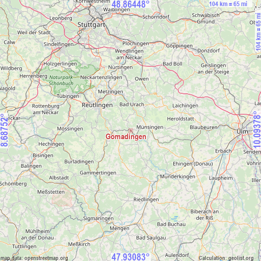
Gomadingen GPS coordinates[2]
48° 23' 59.28" North, 9° 23' 26.34" East
| Map corner | latitude | longitude |
|---|---|---|
| Upper-left | 48.86448°, | 8.68752° |
| Center: | 48.3998°, | 9.39065° |
| Lower-right: | 47.93083°, | 10.09378° |
| Map W x H: | 103.8×103.8 km | = 64.5×64.5mi |
| max Lat: | 55.01917° ⇑90.3% North |
| Gomadingen: | 48.3998° |
| min Lat: | ⇓9.7% South 47.40724° |
| min Long | Gomadingen | max Long |
| 5.92978° | 9.39065° | 14.98853° |
| W 40.6%⇐ | ⇒59.4% E |
Elevation
Elevation of Gomadingen is 664 m = 2178 ft, and this is 414.9 m = 1361 ft above average elevation for this country.
| Max E: |
1256 m = 4121 ft | 2.9% |
| Gomadingen | 664 m 2178 ft | |
| Avg. | 249.1 m = 817 ft | |
Min E: |
-5 m = -16 ft | 97.1% |
See also: Germany elevation on elevation.city.
Geographical zone
Gomadingen is located in North temperate zone (between Tropic of Cancer and the Arctic Circle). Distance of this North polar circle is 2019.6 km =1254.9 mi to North.| Distance of | km | miles | from Gomadingen |
|---|---|---|---|
| North Pole | 4625.5 | 2874.2 | to North |
| Arctic Circle | 2019.6 | 1254.9 | to North |
| Tropic Cancer | 2775.6 | 1724.7 | to South |
| Equator | 5381.6 | 3344 | to South |


Nearby cities:
15 places around Gomadingen: (largest is in red/bold)
• Altes Lager
10.9 km =6.8 mi,  79°
79°
• Bad Urach
10.2 km =6.3 mi,  3°
3°
• Dettingen an der Erms
15 km =9.3 mi,  346°
346°
• Eningen unter Achalm
13.7 km =8.5 mi,  315°
315°
• Grabenstetten
14.8 km =9.2 mi,  20°
20°
• Hayingen
15.3 km =9.5 mi,  155°
155°
• Hülben
13.4 km =8.3 mi,  5°
5°
• Mehrstetten
13.2 km =8.2 mi,  101°
101°
• Münsingen
8 km =5 mi, 80°
• Pfronstetten
13.9 km =8.6 mi,  189°
189°
• Pfullingen
14 km =8.7 mi,  300°
300°
• Reutlingen
17.1 km =10.6 mi,  306°
306°
• Sankt Johann
6.9 km =4.3 mi,  330°
330°
• Trochtelfingen
14.8 km =9.2 mi,  226°
226°
• Unterhausen
10.5 km =6.5 mi,  288°
288°
Sources, notices
• [Note1] Compared only with cities in Germany existing in our database
• [Src1] Map data: © OpenStreetMap contributors (CC-BY-SA)
• [Src2] Other city data from geonames.org with taken over terms of usage.
• [Src3] Geographical zone / Annual Mean Temperature by Robert A. Rohde @ Wikipedia
