Tröndel geodata
Tröndel (Schleswig-Holstein) is a seat of a fourth-order administrative division; located in Germany in Europe/Berlin (GMT+2) time zone. With population of 432 people, there are 9589 cities with bigger population in this country. Compared to other cities in Germany, 96.6% of cities are located further ↓South; 59.1% of cities are located further ←West and 82% of cities have higher elevation than Tröndel. Note1


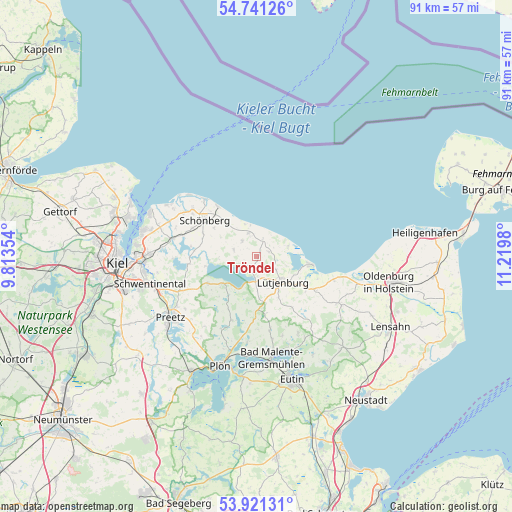
Tröndel GPS coordinates[2]
54° 19' 59.988" North, 10° 31' 0.012" East
| Map corner | latitude | longitude |
|---|---|---|
| Upper-left | 54.74126°, | 9.81354° |
| Center: | 54.33333°, | 10.51667° |
| Lower-right: | 53.92131°, | 11.2198° |
| Map W x H: | 91.2×91.2 km | = 56.7×56.7mi |
| max Lat: | 55.01917° ⇑3.4% North |
| Tröndel: | 54.33333° |
| min Lat: | ⇓96.6% South 47.40724° |
| min Long | Tröndel | max Long |
| 5.92978° | 10.51667° | 14.98853° |
| W 59.1%⇐ | ⇒40.9% E |
Elevation
Elevation of Tröndel is 42 m = 138 ft, and this is 207.1 m = 679 ft below average elevation for this country.
| Max E: |
1256 m = 4121 ft | 82% |
| Avg. | 249.1 m = 817 ft | |
| Tröndel | 42 m = 138 ft | |
Min E: |
-5 m = -16 ft | 18% |
See also: Germany elevation on elevation.city.
Geographical zone
Tröndel is located in North temperate zone (between Tropic of Cancer and the Arctic Circle). Distance of this North polar circle is 1359.9 km =845 mi to North.| Distance of | km | miles | from Tröndel |
|---|---|---|---|
| North Pole | 3965.8 | 2464.2 | to North |
| Arctic Circle | 1359.9 | 845 | to North |
| Tropic Cancer | 3435.4 | 2134.7 | to South |
| Equator | 6041.3 | 3753.9 | to South |


Nearby cities:
15 places around Tröndel: (largest is in red/bold)
• Behrensdorf
6 km =3.7 mi,  71°
71°
• Bendfeld
7.5 km =4.7 mi,  299°
299°
• Fargau-Pratjau
6.5 km =4 mi,  270°
270°
• Giekau
1.9 km =1.2 mi,  180°
180°
• Helmstorf
7.8 km =4.8 mi,  135°
135°
• Hohenfelde
3.9 km =2.4 mi,  343°
343°
• Klamp
3.9 km =2.4 mi,  163°
163°
• Köhn
4.7 km =2.9 mi,  293°
293°
• Lammershagen
7 km =4.3 mi,  217°
217°
• Lütjenburg
6.6 km =4.1 mi,  134°
134°
• Panker
3.2 km =2 mi,  90°
90°
• Rantzau
9.3 km =5.8 mi, 180°
• Schwartbuck
3.7 km =2.3 mi,  317°
317°
• Selent
7.6 km =4.7 mi,  229°
229°
• Stakendorf
8.6 km =5.3 mi, 315°
Sources, notices
• [Note1] Compared only with cities in Germany existing in our database
• [Src1] Map data: © OpenStreetMap contributors (CC-BY-SA)
• [Src2] Other city data from geonames.org with taken over terms of usage.
• [Src3] Geographical zone / Annual Mean Temperature by Robert A. Rohde @ Wikipedia
