Lütjenburg geodata
Lütjenburg (Schleswig-Holstein) is a populated place; located in Germany in Europe/Berlin (GMT+2) time zone. With population of 5,814 people, there are 2525 cities with bigger population in this country. Compared to other cities in Germany, 96.2% of cities are located further ↓South; 60.6% of cities are located further ←West and 83.7% of cities have higher elevation than Lütjenburg. Note1


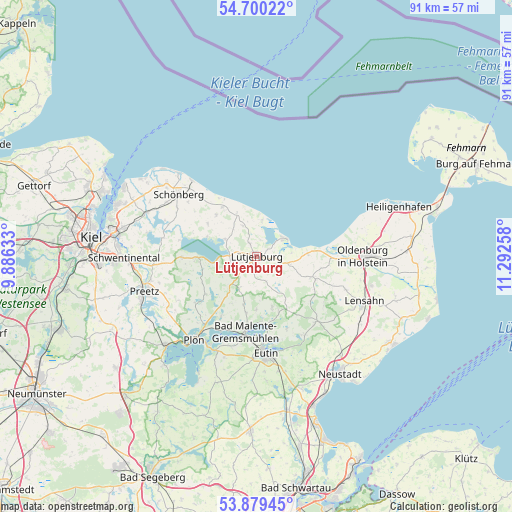
Lütjenburg GPS coordinates[2]
54° 17' 30.768" North, 10° 35' 22.02" East
| Map corner | latitude | longitude |
|---|---|---|
| Upper-left | 54.70022°, | 9.88633° |
| Center: | 54.29188°, | 10.58945° |
| Lower-right: | 53.87945°, | 11.29258° |
| Map W x H: | 91.3×91.3 km | = 56.7×56.7mi |
| max Lat: | 55.01917° ⇑3.8% North |
| Lütjenburg: | 54.29188° |
| min Lat: | ⇓96.2% South 47.40724° |
| min Long | Lütjenburg | max Long |
| 5.92978° | 10.58945° | 14.98853° |
| W 60.6%⇐ | ⇒39.4% E |
Elevation
Elevation of Lütjenburg is 38 m = 125 ft, and this is 211.1 m = 693 ft below average elevation for this country.
| Max E: |
1256 m = 4121 ft | 83.7% |
| Avg. | 249.1 m = 817 ft | |
| Lütjenburg | 38 m = 125 ft | |
Min E: |
-5 m = -16 ft | 16.3% |
See also: Germany elevation on elevation.city.
Geographical zone
Lütjenburg is located in North temperate zone (between Tropic of Cancer and the Arctic Circle). Distance of this North polar circle is 1364.5 km =847.9 mi to North.| Distance of | km | miles | from Lütjenburg |
|---|---|---|---|
| North Pole | 3970.4 | 2467.1 | to North |
| Arctic Circle | 1364.5 | 847.9 | to North |
| Tropic Cancer | 3430.8 | 2131.8 | to South |
| Equator | 6036.7 | 3751 | to South |


Nearby cities:
15 places around Lütjenburg: (largest is in red/bold)
• Behrensdorf
6.6 km =4.1 mi,  8°
8°
• Blekendorf
4.6 km =2.9 mi,  103°
103°
• Dannau
6.5 km =4 mi,  208°
208°
• Giekau
5.5 km =3.4 mi,  300°
300°
• Helmstorf
1.2 km =0.7 mi,  144°
144°
• Hohenfelde
10.1 km =6.3 mi,  325°
325°
• Hohwacht
6.1 km =3.8 mi,  58°
58°
• Högsdorf
5 km =3.1 mi,  159°
159°
• Klamp
3.8 km =2.4 mi,  283°
283°
• Kletkamp
5.5 km =3.4 mi,  148°
148°
• Lammershagen
9.1 km =5.7 mi,  264°
264°
• Neukirchen
8.9 km =5.5 mi,  195°
195°
• Panker
4.8 km =3 mi,  342°
342°
• Rantzau
6.6 km =4.1 mi,  225°
225°
• Tröndel
6.6 km =4.1 mi,  314°
314°
Sources, notices
• [Note1] Compared only with cities in Germany existing in our database
• [Src1] Map data: © OpenStreetMap contributors (CC-BY-SA)
• [Src2] Other city data from geonames.org with taken over terms of usage.
• [Src3] Geographical zone / Annual Mean Temperature by Robert A. Rohde @ Wikipedia
