Trier geodata
Trier (Rheinland-Pfalz) is a seat of a fourth-order administrative division; located in Germany in Europe/Berlin (GMT+2) time zone. With population of 100,129 people, there are 98 cities with bigger population in this country. Compared to other cities in Germany, 70% of cities are located further ↑North; 96.8% of cities are located further →East and 61.6% of cities have higher elevation than Trier. Note1


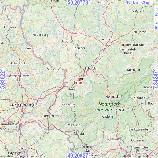
Trier GPS coordinates[2]
49° 45' 20.34" North, 6° 38' 21.66" East
| Map corner | latitude | longitude |
|---|---|---|
| Upper-left | 50.20778°, | 5.93622° |
| Center: | 49.75565°, | 6.63935° |
| Lower-right: | 49.29927°, | 7.34247° |
| Map W x H: | 101×101 km | = 62.8×62.8mi |
| max Lat: | 55.01917° ⇑70% North |
| Trier: | 49.75565° |
| min Lat: | ⇓30% South 47.40724° |
| min Long | Trier | max Long |
| 5.92978° | 6.63935° | 14.98853° |
| W 3.2%⇐ | ⇒96.8% E |
Elevation
Elevation of Trier is 141 m = 463 ft, and this is 108.1 m = 355 ft below average elevation for this country.
| Max E: |
1256 m = 4121 ft | 61.6% |
| Avg. | 249.1 m = 817 ft | |
| Trier | 141 m = 463 ft | |
Min E: |
-5 m = -16 ft | 38.4% |
See also: Trier elevation on elevation.city.
Geographical zone
Trier is located in North temperate zone (between Tropic of Cancer and the Arctic Circle). Distance of this North polar circle is 1868.9 km =1161.3 mi to North.| Distance of | km | miles | from Trier |
|---|---|---|---|
| North Pole | 4474.8 | 2780.5 | to North |
| Arctic Circle | 1868.9 | 1161.3 | to North |
| Tropic Cancer | 2926.4 | 1818.4 | to South |
| Equator | 5532.3 | 3437.6 | to South |


Nearby cities:
15 places around Trier: (largest is in red/bold)
• Aach
4.2 km =2.6 mi,  317°
317°
• Gutweiler
8 km =5 mi,  122°
122°
• Hockweiler
7 km =4.3 mi,  147°
147°
• Igel
7.9 km =4.9 mi,  230°
230°
• Irsch
5.3 km =3.3 mi,  127°
127°
• Kasel
6.7 km =4.2 mi,  84°
84°
• Kenn
7.4 km =4.6 mi,  48°
48°
• Konz
7.6 km =4.7 mi,  216°
216°
• Korlingen
6.9 km =4.3 mi, 117°
• Mertesdorf
7 km =4.3 mi,  74°
74°
• Morscheid
8.3 km =5.2 mi,  107°
107°
• Newel
7.5 km =4.7 mi,  327°
327°
• Sommerau
8 km =5 mi, 122°
• Trierweiler
5.8 km =3.6 mi,  277°
277°
• Waldrach
7.7 km =4.8 mi,  97°
97°
In other languages:
- In Spanish: Tréveris
- In France: Trèves
- In Italian: Treviri
- In Russian: Трир
- In Chinese: 特里尔
Sources, notices
• [Note1] Compared only with cities in Germany existing in our database
• [Src1] Map data: © OpenStreetMap contributors (CC-BY-SA)
• [Src2] Other city data from geonames.org with taken over terms of usage.
• [Src3] Geographical zone / Annual Mean Temperature by Robert A. Rohde @ Wikipedia
