Aach geodata
Aach (Rheinland-Pfalz) is a seat of a fourth-order administrative division; located in Germany in Europe/Berlin (GMT+2) time zone. With population of 1,151 people, there are 6698 cities with bigger population in this country. Compared to other cities in Germany, 69.4% of cities are located further ↑North; 97.1% of cities are located further →East and 50.1% of cities have lower elevation than Aach. Note1
Administrative division(s):
- Level 1: Rheinland-Pfalz
- Level 3: Landkreis Trier-Saarburg
- Level 4: Aach


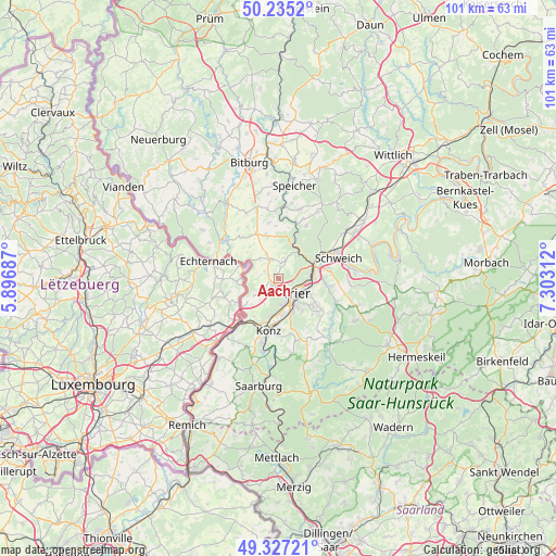
Aach GPS coordinates[2]
49° 46' 59.988" North, 6° 36' 0" East
| Map corner | latitude | longitude |
|---|---|---|
| Upper-left | 50.2352°, | 5.89687° |
| Center: | 49.78333°, | 6.6° |
| Lower-right: | 49.32721°, | 7.30312° |
| Map W x H: | 101×101 km | = 62.8×62.8mi |
| max Lat: | 55.01917° ⇑69.4% North |
| Aach: | 49.78333° |
| min Lat: | ⇓30.6% South 47.40724° |
| min Long | Aach | max Long |
| 5.92978° | 6.6° | 14.98853° |
| W 2.9%⇐ | ⇒97.1% E |
Elevation
Elevation of Aach is 226 m = 741 ft, and this is 23.1 m = 76 ft below average elevation for this country.
| Max E: |
1256 m = 4121 ft | 49.9% |
| Avg. | 249.1 m = 817 ft | |
| Aach | 226 m = 741 ft | |
Min E: |
-5 m = -16 ft | 50.1% |
See also: Germany elevation on elevation.city.
Geographical zone
Aach is located in North temperate zone (between Tropic of Cancer and the Arctic Circle). Distance of this North polar circle is 1865.8 km =1159.4 mi to North.| Distance of | km | miles | from Aach |
|---|---|---|---|
| North Pole | 4471.7 | 2778.6 | to North |
| Arctic Circle | 1865.8 | 1159.4 | to North |
| Tropic Cancer | 2929.5 | 1820.3 | to South |
| Equator | 5535.4 | 3439.5 | to South |


Nearby cities:
15 places around Aach: (largest is in red/bold)
• Eisenach
9.5 km =5.9 mi,  321°
321°
• Igel
8.7 km =5.4 mi,  201°
201°
• Irsch
9.5 km =5.9 mi,  132°
132°
• Kasel
9.8 km =6.1 mi,  104°
104°
• Kenn
8.6 km =5.3 mi,  77°
77°
• Konz
9.4 km =5.8 mi,  190°
190°
• Kordel
6.1 km =3.8 mi,  23°
23°
• Langsur
9.8 km =6.1 mi,  227°
227°
• Mertesdorf
9.6 km =6 mi, 97°
• Newel
3.5 km =2.2 mi,  339°
339°
• Ralingen
8.1 km =5 mi,  297°
297°
• Trier
4.2 km =2.6 mi,  137°
137°
• Trierweiler
3.7 km =2.3 mi, 230°
• Wasserliesch
9.5 km =5.9 mi,  207°
207°
• Welschbillig
7.8 km =4.8 mi, 342°
Sources, notices
• [Note1] Compared only with cities in Germany existing in our database
• [Src1] Map data: © OpenStreetMap contributors (CC-BY-SA)
• [Src2] Other city data from geonames.org with taken over terms of usage.
• [Src3] Geographical zone / Annual Mean Temperature by Robert A. Rohde @ Wikipedia
