Igel geodata
Igel (Rheinland-Pfalz) is a seat of a fourth-order administrative division; located in Germany in Europe/Berlin (GMT+2) time zone. With population of 2,003 people, there are 5066 cities with bigger population in this country. Compared to other cities in Germany, 71.1% of cities are located further ↑North; 97.4% of cities are located further →East and 59.7% of cities have higher elevation than Igel. Note1
Administrative division(s):
- Level 1: Rheinland-Pfalz
- Level 3: Landkreis Trier-Saarburg
- Level 4: Igel


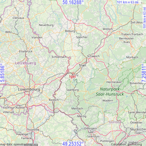
Igel GPS coordinates[2]
49° 42' 37.188" North, 6° 33' 17.928" East
| Map corner | latitude | longitude |
|---|---|---|
| Upper-left | 50.16288°, | 5.85186° |
| Center: | 49.71033°, | 6.55498° |
| Lower-right: | 49.25352°, | 7.25811° |
| Map W x H: | 101.1×101.1 km | = 62.8×62.8mi |
| max Lat: | 55.01917° ⇑71.1% North |
| Igel: | 49.71033° |
| min Lat: | ⇓28.9% South 47.40724° |
| min Long | Igel | max Long |
| 5.92978° | 6.55498° | 14.98853° |
| W 2.6%⇐ | ⇒97.4% E |
Elevation
Elevation of Igel is 155 m = 509 ft, and this is 94.1 m = 309 ft below average elevation for this country.
| Max E: |
1256 m = 4121 ft | 59.7% |
| Avg. | 249.1 m = 817 ft | |
| Igel | 155 m = 509 ft | |
Min E: |
-5 m = -16 ft | 40.3% |
See also: Germany elevation on elevation.city.
Geographical zone
Igel is located in North temperate zone (between Tropic of Cancer and the Arctic Circle). Distance of this North polar circle is 1873.9 km =1164.4 mi to North.| Distance of | km | miles | from Igel |
|---|---|---|---|
| North Pole | 4479.8 | 2783.6 | to North |
| Arctic Circle | 1873.9 | 1164.4 | to North |
| Tropic Cancer | 2921.4 | 1815.3 | to South |
| Equator | 5527.3 | 3434.5 | to South |


Nearby cities:
15 places around Igel: (largest is in red/bold)
• Aach
8.7 km =5.4 mi,  21°
21°
• Ayl
8.6 km =5.3 mi,  182°
182°
• Kanzem
5.1 km =3.2 mi,  160°
160°
• Konz
1.9 km =1.2 mi,  125°
125°
• Langsur
4.3 km =2.7 mi,  291°
291°
• Oberbillig
3.5 km =2.2 mi,  268°
268°
• Onsdorf
8.5 km =5.3 mi,  217°
217°
• Schoden
8.8 km =5.5 mi,  166°
166°
• Tawern
5.6 km =3.5 mi,  209°
209°
• Temmels
6.9 km =4.3 mi,  249°
249°
• Trier
7.9 km =4.9 mi,  50°
50°
• Trierweiler
5.8 km =3.6 mi,  3°
3°
• Wasserliesch
1.2 km =0.7 mi, 253°
• Wawern
6.7 km =4.2 mi, 183°
• Wiltingen
6.3 km =3.9 mi,  154°
154°
Sources, notices
• [Note1] Compared only with cities in Germany existing in our database
• [Src1] Map data: © OpenStreetMap contributors (CC-BY-SA)
• [Src2] Other city data from geonames.org with taken over terms of usage.
• [Src3] Geographical zone / Annual Mean Temperature by Robert A. Rohde @ Wikipedia
