Alt-Treptow geodata
Alt-Treptow (Berlin) is a section of populated place; located in Germany in Europe/Berlin (GMT+2) time zone. With population of 10,859 people, there are 1518 cities with bigger population in this country. Compared to other cities in Germany, 77.3% of cities are located further ↓South; 95.5% of cities are located further ←West and 84.5% of cities have higher elevation than Alt-Treptow. Note1


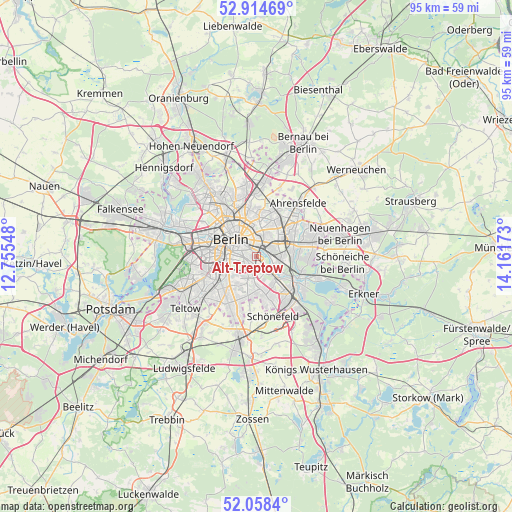
Alt-Treptow GPS coordinates[2]
52° 29' 19.068" North, 13° 27' 30.96" East
| Map corner | latitude | longitude |
|---|---|---|
| Upper-left | 52.91469°, | 12.75548° |
| Center: | 52.48863°, | 13.4586° |
| Lower-right: | 52.0584°, | 14.16173° |
| Map W x H: | 95.2×95.2 km | = 59.2×59.2mi |
| max Lat: | 55.01917° ⇑22.7% North |
| Alt-Treptow: | 52.48863° |
| min Lat: | ⇓77.3% South 47.40724° |
| min Long | Alt-Treptow | max Long |
| 5.92978° | 13.4586° | 14.98853° |
| W 95.5%⇐ | ⇒4.5% E |
Elevation
Elevation of Alt-Treptow is 36 m = 118 ft, and this is 213.1 m = 699 ft below average elevation for this country.
| Max E: |
1256 m = 4121 ft | 84.5% |
| Avg. | 249.1 m = 817 ft | |
| Alt-Treptow | 36 m = 118 ft | |
Min E: |
-5 m = -16 ft | 15.5% |
See also: Germany elevation on elevation.city.
Geographical zone
Alt-Treptow is located in North temperate zone (between Tropic of Cancer and the Arctic Circle). Distance of this North polar circle is 1565 km =972.4 mi to North.| Distance of | km | miles | from Alt-Treptow |
|---|---|---|---|
| North Pole | 4170.9 | 2591.7 | to North |
| Arctic Circle | 1565 | 972.4 | to North |
| Tropic Cancer | 3230.3 | 2007.2 | to South |
| Equator | 5836.2 | 3626.4 | to South |


Nearby cities:
15 places around Alt-Treptow: (largest is in red/bold)
• Baumschulenweg
3.1 km =1.9 mi,  144°
144°
• Berlin
5.1 km =3.2 mi,  320°
320°
• Berlin Treptow
1.1 km =0.7 mi,  301°
301°
• Fennpfuhl
4.6 km =2.9 mi,  11°
11°
• Friedrichsfelde
3.9 km =2.4 mi,  60°
60°
• Friedrichshain
3 km =1.9 mi,  355°
355°
• Karlshorst
5 km =3.1 mi,  95°
95°
• Kreuzberg
3.9 km =2.4 mi,  288°
288°
• Lichtenberg
4 km =2.5 mi,  44°
44°
• Mitte
5 km =3.1 mi,  313°
313°
• Neukölln
2.2 km =1.4 mi,  235°
235°
• Oberschöneweide
5.2 km =3.2 mi,  125°
125°
• Plänterwald
1.3 km =0.8 mi, 131°
• Rummelsburg
2.8 km =1.7 mi, 58°
• Tempelhof
4.7 km =2.9 mi, 238°
Sources, notices
• [Note1] Compared only with cities in Germany existing in our database
• [Src1] Map data: © OpenStreetMap contributors (CC-BY-SA)
• [Src2] Other city data from geonames.org with taken over terms of usage.
• [Src3] Geographical zone / Annual Mean Temperature by Robert A. Rohde @ Wikipedia
