Fennpfuhl geodata
Fennpfuhl (Berlin) is a section of populated place; located in Germany in Europe/Berlin (GMT+2) time zone. With population of 31,529 people, there are 439 cities with bigger population in this country. Compared to other cities in Germany, 77.8% of cities are located further ↓South; 95.6% of cities are located further ←West and 74.7% of cities have higher elevation than Fennpfuhl. Note1


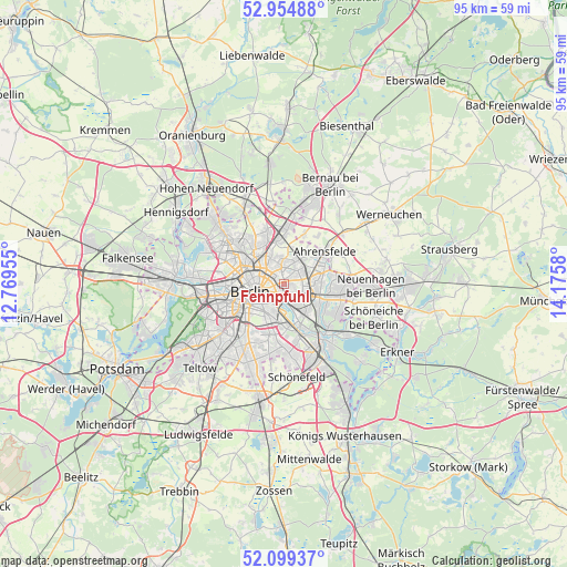
Fennpfuhl GPS coordinates[2]
52° 31' 45.156" North, 13° 28' 21.612" East
| Map corner | latitude | longitude |
|---|---|---|
| Upper-left | 52.95488°, | 12.76955° |
| Center: | 52.52921°, | 13.47267° |
| Lower-right: | 52.09937°, | 14.1758° |
| Map W x H: | 95.1×95.1 km | = 59.1×59.1mi |
| max Lat: | 55.01917° ⇑22.2% North |
| Fennpfuhl: | 52.52921° |
| min Lat: | ⇓77.8% South 47.40724° |
| min Long | Fennpfuhl | max Long |
| 5.92978° | 13.47267° | 14.98853° |
| W 95.6%⇐ | ⇒4.4% E |
Elevation
Elevation of Fennpfuhl is 64 m = 210 ft, and this is 185.1 m = 607 ft below average elevation for this country.
| Max E: |
1256 m = 4121 ft | 74.7% |
| Avg. | 249.1 m = 817 ft | |
| Fennpfuhl | 64 m = 210 ft | |
Min E: |
-5 m = -16 ft | 25.3% |
See also: Germany elevation on elevation.city.
Geographical zone
Fennpfuhl is located in North temperate zone (between Tropic of Cancer and the Arctic Circle). Distance of this North polar circle is 1560.5 km =969.6 mi to North.| Distance of | km | miles | from Fennpfuhl |
|---|---|---|---|
| North Pole | 4166.4 | 2588.9 | to North |
| Arctic Circle | 1560.5 | 969.6 | to North |
| Tropic Cancer | 3234.8 | 2010 | to South |
| Equator | 5840.7 | 3629.2 | to South |


Nearby cities:
15 places around Fennpfuhl: (largest is in red/bold)
• Alt-Hohenschönhausen
2.7 km =1.7 mi,  45°
45°
• Alt-Treptow
4.6 km =2.9 mi,  191°
191°
• Berlin
4.2 km =2.6 mi,  262°
262°
• Berlin Treptow
4.4 km =2.7 mi,  205°
205°
• Friedrichsfelde
3.5 km =2.2 mi,  137°
137°
• Friedrichshain
1.9 km =1.2 mi,  218°
218°
• Heinersdorf
5.3 km =3.3 mi,  333°
333°
• Kreuzberg
5.7 km =3.5 mi,  235°
235°
• Lichtenberg
2.5 km =1.6 mi,  132°
132°
• Mitte
4.7 km =2.9 mi, 257°
• Neu-Hohenschönhausen
5 km =3.1 mi,  32°
32°
• Plänterwald
5.4 km =3.4 mi,  179°
179°
• Prenzlauer Berg
3.4 km =2.1 mi,  288°
288°
• Rummelsburg
3.4 km =2.1 mi,  155°
155°
• Weißensee
3 km =1.9 mi,  352°
352°
Sources, notices
• [Note1] Compared only with cities in Germany existing in our database
• [Src1] Map data: © OpenStreetMap contributors (CC-BY-SA)
• [Src2] Other city data from geonames.org with taken over terms of usage.
• [Src3] Geographical zone / Annual Mean Temperature by Robert A. Rohde @ Wikipedia
