Ahrensburg geodata
Ahrensburg (Schleswig-Holstein) is a populated place; located in Germany in Europe/Berlin (GMT+2) time zone. With population of 30,103 people, there are 462 cities with bigger population in this country. Compared to other cities in Germany, 88.2% of cities are located further ↓South; 53.9% of cities are located further ←West and 81% of cities have higher elevation than Ahrensburg. Note1


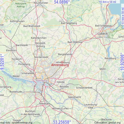
Ahrensburg GPS coordinates[2]
53° 40' 30.54" North, 10° 13' 33.348" East
| Map corner | latitude | longitude |
|---|---|---|
| Upper-left | 54.0896°, | 9.52281° |
| Center: | 53.67515°, | 10.22593° |
| Lower-right: | 53.25658°, | 10.92906° |
| Map W x H: | 92.6×92.6 km | = 57.5×57.5mi |
| max Lat: | 55.01917° ⇑11.8% North |
| Ahrensburg: | 53.67515° |
| min Lat: | ⇓88.2% South 47.40724° |
| min Long | Ahrensburg | max Long |
| 5.92978° | 10.22593° | 14.98853° |
| W 53.9%⇐ | ⇒46.1% E |
Elevation
Elevation of Ahrensburg is 44 m = 144 ft, and this is 205.1 m = 673 ft below average elevation for this country.
| Max E: |
1256 m = 4121 ft | 81% |
| Avg. | 249.1 m = 817 ft | |
| Ahrensburg | 44 m = 144 ft | |
Min E: |
-5 m = -16 ft | 19% |
See also: Germany elevation on elevation.city.
Geographical zone
Ahrensburg is located in North temperate zone (between Tropic of Cancer and the Arctic Circle). Distance of this North polar circle is 1433.1 km =890.5 mi to North.| Distance of | km | miles | from Ahrensburg |
|---|---|---|---|
| North Pole | 4038.9 | 2509.7 | to North |
| Arctic Circle | 1433.1 | 890.5 | to North |
| Tropic Cancer | 3362.2 | 2089.2 | to South |
| Equator | 5968.1 | 3708.4 | to South |


Nearby cities:
15 places around Ahrensburg: (largest is in red/bold)
• Bargteheide
6.5 km =4 mi,  24°
24°
• Bergstedt
6.5 km =4 mi,  266°
266°
• Braak
7.4 km =4.6 mi,  170°
170°
• Delingsdorf
3.2 km =2 mi,  29°
29°
• Duvenstedt
8.8 km =5.5 mi,  294°
294°
• Großhansdorf
3.9 km =2.4 mi,  104°
104°
• Hammoor
7.6 km =4.7 mi,  55°
55°
• Hoisdorf
6.6 km =4.1 mi,  115°
115°
• Jersbek
6.5 km =4 mi,  354°
354°
• Lemsahl-Mellingstedt
8.7 km =5.4 mi,  280°
280°
• Sasel
7.9 km =4.9 mi,  252°
252°
• Siek
6.7 km =4.2 mi,  133°
133°
• Stapelfeld
8.4 km =5.2 mi,  184°
184°
• Todendorf
8.3 km =5.2 mi,  74°
74°
• Wohldorf-Ohlstedt
6.5 km =4 mi, 287°
Sources, notices
• [Note1] Compared only with cities in Germany existing in our database
• [Src1] Map data: © OpenStreetMap contributors (CC-BY-SA)
• [Src2] Other city data from geonames.org with taken over terms of usage.
• [Src3] Geographical zone / Annual Mean Temperature by Robert A. Rohde @ Wikipedia
