Themar geodata
Themar (Thuringia) is a populated place; located in Germany in Europe/Berlin (GMT+2) time zone. With population of 3,083 people, there are 3928 cities with bigger population in this country. Compared to other cities in Germany, 52.7% of cities are located further ↑North; 61% of cities are located further ←West and 66.2% of cities have lower elevation than Themar. Note1


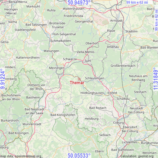
Themar GPS coordinates[2]
50° 30' 16.74" North, 10° 36' 55.296" East
| Map corner | latitude | longitude |
|---|---|---|
| Upper-left | 50.94973°, | 9.91224° |
| Center: | 50.50465°, | 10.61536° |
| Lower-right: | 50.05533°, | 11.31849° |
| Map W x H: | 99.4×99.4 km | = 61.8×61.8mi |
| max Lat: | 55.01917° ⇑52.7% North |
| Themar: | 50.50465° |
| min Lat: | ⇓47.3% South 47.40724° |
| min Long | Themar | max Long |
| 5.92978° | 10.61536° | 14.98853° |
| W 61%⇐ | ⇒39% E |
Elevation
Elevation of Themar is 330 m = 1083 ft, and this is 80.9 m = 265 ft above average elevation for this country.
| Max E: |
1256 m = 4121 ft | 33.8% |
| Themar | 330 m 1083 ft | |
| Avg. | 249.1 m = 817 ft | |
Min E: |
-5 m = -16 ft | 66.2% |
See also: Germany elevation on elevation.city.
Geographical zone
Themar is located in North temperate zone (between Tropic of Cancer and the Arctic Circle). Distance of this North polar circle is 1785.6 km =1109.5 mi to North.| Distance of | km | miles | from Themar |
|---|---|---|---|
| North Pole | 4391.5 | 2728.8 | to North |
| Arctic Circle | 1785.6 | 1109.5 | to North |
| Tropic Cancer | 3009.7 | 1870.1 | to South |
| Equator | 5615.6 | 3489.4 | to South |


Nearby cities:
15 places around Themar: (largest is in red/bold)
• Ahlstädt
5.8 km =3.6 mi,  56°
56°
• Beinerstadt
4.4 km =2.7 mi,  194°
194°
• Bischofrod
5.6 km =3.5 mi,  25°
25°
• Ehrenberg
3.4 km =2.1 mi,  134°
134°
• Eichenberg
6.2 km =3.9 mi,  35°
35°
• Grimmelshausen
2.7 km =1.7 mi,  151°
151°
• Grub
5.2 km =3.2 mi,  14°
14°
• Henfstädt
2.4 km =1.5 mi,  303°
303°
• Kloster Veßra
2.5 km =1.6 mi,  101°
101°
• Lengfeld
4 km =2.5 mi, 37°
• Leutersdorf
4.8 km =3 mi,  286°
286°
• Marisfeld
6.4 km =4 mi,  332°
332°
• Oberstadt
5.8 km =3.6 mi,  348°
348°
• Reurieth
6.6 km =4.1 mi,  158°
158°
• Vachdorf
6 km =3.7 mi, 293°
Sources, notices
• [Note1] Compared only with cities in Germany existing in our database
• [Src1] Map data: © OpenStreetMap contributors (CC-BY-SA)
• [Src2] Other city data from geonames.org with taken over terms of usage.
• [Src3] Geographical zone / Annual Mean Temperature by Robert A. Rohde @ Wikipedia
