Eichenberg geodata
Eichenberg (Thuringia) is a seat of a fourth-order administrative division; located in Germany in Europe/Berlin (GMT+2) time zone. With population of 183 people, there are 10546 cities with bigger population in this country. Compared to other cities in Germany, 51.7% of cities are located further ↑North; 61.9% of cities are located further ←West and 86% of cities have lower elevation than Eichenberg. Note1
Administrative division(s):
- Level 1: Thuringia
- Level 3: Landkreis Hildburghausen
- Level 4: Eichenberg


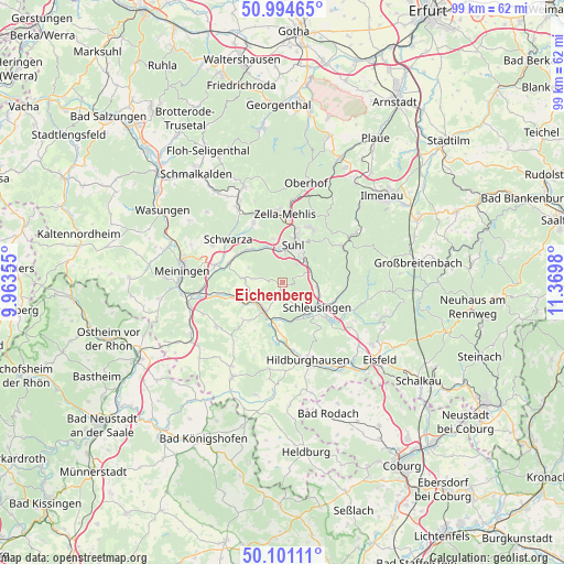
Eichenberg GPS coordinates[2]
50° 33' 0" North, 10° 40' 0.012" East
| Map corner | latitude | longitude |
|---|---|---|
| Upper-left | 50.99465°, | 9.96355° |
| Center: | 50.55°, | 10.66667° |
| Lower-right: | 50.10111°, | 11.3698° |
| Map W x H: | 99.4×99.4 km | = 61.8×61.8mi |
| max Lat: | 55.01917° ⇑51.7% North |
| Eichenberg: | 50.55° |
| min Lat: | ⇓48.3% South 47.40724° |
| min Long | Eichenberg | max Long |
| 5.92978° | 10.66667° | 14.98853° |
| W 61.9%⇐ | ⇒38.1% E |
Elevation
Elevation of Eichenberg is 478 m = 1568 ft, and this is 228.9 m = 751 ft above average elevation for this country.
| Max E: |
1256 m = 4121 ft | 14% |
| Eichenberg | 478 m 1568 ft | |
| Avg. | 249.1 m = 817 ft | |
Min E: |
-5 m = -16 ft | 86% |
See also: Germany elevation on elevation.city.
Geographical zone
Eichenberg is located in North temperate zone (between Tropic of Cancer and the Arctic Circle). Distance of this North polar circle is 1780.5 km =1106.4 mi to North.| Distance of | km | miles | from Eichenberg |
|---|---|---|---|
| North Pole | 4386.4 | 2725.6 | to North |
| Arctic Circle | 1780.5 | 1106.4 | to North |
| Tropic Cancer | 3014.7 | 1873.2 | to South |
| Equator | 5620.6 | 3492.5 | to South |


Nearby cities:
15 places around Eichenberg: (largest is in red/bold)
• Ahlstädt
2.2 km =1.4 mi,  147°
147°
• Bischofrod
1.2 km =0.7 mi,  270°
270°
• Ehrenberg
7.5 km =4.7 mi,  189°
189°
• Grimmelshausen
7.8 km =4.8 mi,  197°
197°
• Grub
2.4 km =1.5 mi, 270°
• Henfstädt
6.7 km =4.2 mi,  236°
236°
• Kloster Veßra
5.7 km =3.5 mi, 191°
• Lengfeld
2.2 km =1.4 mi,  212°
212°
• Marisfeld
6.7 km =4.2 mi,  275°
275°
• Oberstadt
4.9 km =3 mi, 276°
• Sankt Kilian
7.3 km =4.5 mi,  110°
110°
• Schleusingen
7.7 km =4.8 mi,  124°
124°
• Schmeheim
6.2 km =3.9 mi,  287°
287°
• Suhl
6.9 km =4.3 mi,  16°
16°
• Themar
6.2 km =3.9 mi,  215°
215°
Sources, notices
• [Note1] Compared only with cities in Germany existing in our database
• [Src1] Map data: © OpenStreetMap contributors (CC-BY-SA)
• [Src2] Other city data from geonames.org with taken over terms of usage.
• [Src3] Geographical zone / Annual Mean Temperature by Robert A. Rohde @ Wikipedia
