Geesthacht geodata
Geesthacht (Schleswig-Holstein) is a populated place; located in Germany in Europe/Berlin (GMT+2) time zone. With population of 29,487 people, there are 478 cities with bigger population in this country. Compared to other cities in Germany, 84.9% of cities are located further ↓South; 56.8% of cities are located further ←West and 88.3% of cities have higher elevation than Geesthacht. Note1
Administrative division(s):
- Level 1: Schleswig-Holstein
- Level 3: Kreis Herzogtum Lauenburg
- Level 4: Geesthacht


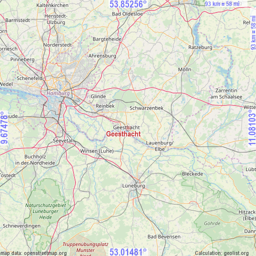
Geesthacht GPS coordinates[2]
53° 26' 8.7" North, 10° 22' 40.44" East
| Map corner | latitude | longitude |
|---|---|---|
| Upper-left | 53.85256°, | 9.67478° |
| Center: | 53.43575°, | 10.3779° |
| Lower-right: | 53.01481°, | 11.08103° |
| Map W x H: | 93.1×93.1 km | = 57.8×57.8mi |
| max Lat: | 55.01917° ⇑15.1% North |
| Geesthacht: | 53.43575° |
| min Lat: | ⇓84.9% South 47.40724° |
| min Long | Geesthacht | max Long |
| 5.92978° | 10.3779° | 14.98853° |
| W 56.8%⇐ | ⇒43.2% E |
Elevation
Elevation of Geesthacht is 26 m = 85 ft, and this is 223.1 m = 732 ft below average elevation for this country.
| Max E: |
1256 m = 4121 ft | 88.3% |
| Avg. | 249.1 m = 817 ft | |
| Geesthacht | 26 m = 85 ft | |
Min E: |
-5 m = -16 ft | 11.7% |
See also: Germany elevation on elevation.city.
Geographical zone
Geesthacht is located in North temperate zone (between Tropic of Cancer and the Arctic Circle). Distance of this North polar circle is 1459.7 km =907 mi to North.| Distance of | km | miles | from Geesthacht |
|---|---|---|---|
| North Pole | 4065.6 | 2526.2 | to North |
| Arctic Circle | 1459.7 | 907 | to North |
| Tropic Cancer | 3335.6 | 2072.6 | to South |
| Equator | 5941.5 | 3691.9 | to South |


Nearby cities:
15 places around Geesthacht: (largest is in red/bold)
• Brunstorf
7.1 km =4.4 mi,  26°
26°
• Börnsen
7.8 km =4.8 mi,  305°
305°
• Dassendorf
6.7 km =4.2 mi,  349°
349°
• Drage
7.7 km =4.8 mi,  253°
253°
• Escheburg
5.3 km =3.3 mi, 310°
• Gülzow
8.2 km =5.1 mi,  78°
78°
• Hamwarde
3 km =1.9 mi,  58°
58°
• Hohenhorn
4.6 km =2.9 mi, 348°
• Kollow
6.8 km =4.2 mi, 59°
• Krukow
7.3 km =4.5 mi,  106°
106°
• Kröppelshagen-Fahrendorf
7.2 km =4.5 mi,  326°
326°
• Marschacht
2.3 km =1.4 mi,  184°
184°
• Tespe
4.9 km =3 mi,  153°
153°
• Wiershop
4.8 km =3 mi,  93°
93°
• Worth
4.3 km =2.7 mi,  36°
36°
Sources, notices
• [Note1] Compared only with cities in Germany existing in our database
• [Src1] Map data: © OpenStreetMap contributors (CC-BY-SA)
• [Src2] Other city data from geonames.org with taken over terms of usage.
• [Src3] Geographical zone / Annual Mean Temperature by Robert A. Rohde @ Wikipedia
