Struxdorf geodata
Struxdorf (Schleswig-Holstein) is a seat of a fourth-order administrative division; located in Germany in Europe/Berlin (GMT+2) time zone. With population of 683 people, there are 8401 cities with bigger population in this country. Compared to other cities in Germany, 98.7% of cities are located further ↓South; 55.5% of cities are located further →East and 82% of cities have higher elevation than Struxdorf. Note1
Administrative division(s):
- Level 1: Schleswig-Holstein
- Level 3: Kreis Schleswig-Flensburg
- Level 4: Struxdorf


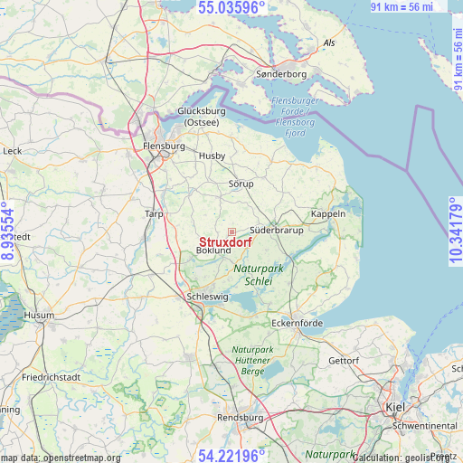
Struxdorf GPS coordinates[2]
54° 37' 51.6" North, 9° 38' 19.176" East
| Map corner | latitude | longitude |
|---|---|---|
| Upper-left | 55.03596°, | 8.93554° |
| Center: | 54.631°, | 9.63866° |
| Lower-right: | 54.22196°, | 10.34179° |
| Map W x H: | 90.5×90.5 km | = 56.2×56.2mi |
| max Lat: | 55.01917° ⇑1.3% North |
| Struxdorf: | 54.631° |
| min Lat: | ⇓98.7% South 47.40724° |
| min Long | Struxdorf | max Long |
| 5.92978° | 9.63866° | 14.98853° |
| W 44.5%⇐ | ⇒55.5% E |
Elevation
Elevation of Struxdorf is 42 m = 138 ft, and this is 207.1 m = 679 ft below average elevation for this country.
| Max E: |
1256 m = 4121 ft | 82% |
| Avg. | 249.1 m = 817 ft | |
| Struxdorf | 42 m = 138 ft | |
Min E: |
-5 m = -16 ft | 18% |
See also: Germany elevation on elevation.city.
Geographical zone
Struxdorf is located in North temperate zone (between Tropic of Cancer and the Arctic Circle). Distance of this North polar circle is 1326.8 km =824.4 mi to North.| Distance of | km | miles | from Struxdorf |
|---|---|---|---|
| North Pole | 3932.7 | 2443.7 | to North |
| Arctic Circle | 1326.8 | 824.4 | to North |
| Tropic Cancer | 3468.5 | 2155.2 | to South |
| Equator | 6074.4 | 3774.5 | to South |


Nearby cities:
15 places around Struxdorf: (largest is in red/bold)
• Brebel
7.2 km =4.5 mi,  87°
87°
• Böel
5.4 km =3.4 mi,  67°
67°
• Böklund
5 km =3.1 mi,  225°
225°
• Havetoftloit
6.1 km =3.8 mi,  303°
303°
• Klappholz
5.9 km =3.7 mi,  254°
254°
• Loit
4.3 km =2.7 mi,  111°
111°
• Mohrkirch
6.4 km =4 mi,  51°
51°
• Satrup
7.1 km =4.4 mi,  342°
342°
• Schnarup-Thumby
2.2 km =1.4 mi,  19°
19°
• Stolk
6.7 km =4.2 mi,  238°
238°
• Süderfahrenstedt
6.4 km =4 mi,  213°
213°
• Taarstedt
7.7 km =4.8 mi,  158°
158°
• Tolk
5.7 km =3.5 mi,  180°
180°
• Twedt
4.5 km =2.8 mi,  140°
140°
• Ülsby
2.5 km =1.6 mi,  275°
275°
Sources, notices
• [Note1] Compared only with cities in Germany existing in our database
• [Src1] Map data: © OpenStreetMap contributors (CC-BY-SA)
• [Src2] Other city data from geonames.org with taken over terms of usage.
• [Src3] Geographical zone / Annual Mean Temperature by Robert A. Rohde @ Wikipedia
