Steina geodata
Steina (Saxony) is a seat of a fourth-order administrative division; located in Germany in Europe/Berlin (GMT+2) time zone. With population of 1,842 people, there are 5287 cities with bigger population in this country. Compared to other cities in Germany, 61.5% of cities are located further ↓South; 98.1% of cities are located further ←West and 64.9% of cities have lower elevation than Steina. Note1


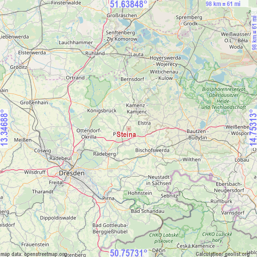
Steina GPS coordinates[2]
51° 12' 0" North, 14° 3' 0" East
| Map corner | latitude | longitude |
|---|---|---|
| Upper-left | 51.63848°, | 13.34688° |
| Center: | 51.2°, | 14.05° |
| Lower-right: | 50.75731°, | 14.75313° |
| Map W x H: | 98×98 km | = 60.9×60.9mi |
| max Lat: | 55.01917° ⇑38.5% North |
| Steina: | 51.2° |
| min Lat: | ⇓61.5% South 47.40724° |
| min Long | Steina | max Long |
| 5.92978° | 14.05° | 14.98853° |
| W 98.1%⇐ | ⇒1.9% E |
Elevation
Elevation of Steina is 320 m = 1050 ft, and this is 70.9 m = 233 ft above average elevation for this country.
| Max E: |
1256 m = 4121 ft | 35.1% |
| Steina | 320 m 1050 ft | |
| Avg. | 249.1 m = 817 ft | |
Min E: |
-5 m = -16 ft | 64.9% |
See also: Germany elevation on elevation.city.
Geographical zone
Steina is located in North temperate zone (between Tropic of Cancer and the Arctic Circle). Distance of this North polar circle is 1708.3 km =1061.5 mi to North.| Distance of | km | miles | from Steina |
|---|---|---|---|
| North Pole | 4314.2 | 2680.7 | to North |
| Arctic Circle | 1708.3 | 1061.5 | to North |
| Tropic Cancer | 3087 | 1918.2 | to South |
| Equator | 5692.9 | 3537.4 | to South |


Nearby cities:
15 places around Steina: (largest is in red/bold)
• Burkau
9 km =5.6 mi,  107°
107°
• Elstra
6.2 km =3.9 mi,  67°
67°
• Frankenthal
8.7 km =5.4 mi,  151°
151°
• Großnaundorf
8.1 km =5 mi,  270°
270°
• Großröhrsdorf
6.5 km =4 mi,  199°
199°
• Haselbachtal
4.3 km =2.7 mi,  336°
336°
• Hauswalde
5.9 km =3.7 mi, 154°
• Höckendorf
10.2 km =6.3 mi,  285°
285°
• Kamenz
8.1 km =5 mi,  21°
21°
• Lichtenberg
6.1 km =3.8 mi,  252°
252°
• Nebelschütz
10.2 km =6.3 mi,  47°
47°
• Neukirch
10.4 km =6.5 mi,  333°
333°
• Oberlichtenau
4.7 km =2.9 mi,  296°
296°
• Ohorn
3.1 km =1.9 mi,  184°
184°
• Rammenau
8 km =5 mi,  133°
133°
Sources, notices
• [Note1] Compared only with cities in Germany existing in our database
• [Src1] Map data: © OpenStreetMap contributors (CC-BY-SA)
• [Src2] Other city data from geonames.org with taken over terms of usage.
• [Src3] Geographical zone / Annual Mean Temperature by Robert A. Rohde @ Wikipedia
