Elstra geodata
Elstra (Saxony) is a populated place; located in Germany in Europe/Berlin (GMT+2) time zone. With population of 3,176 people, there are 3848 cities with bigger population in this country. Compared to other cities in Germany, 61.8% of cities are located further ↓South; 98.4% of cities are located further ←West and 50.7% of cities have higher elevation than Elstra. Note1


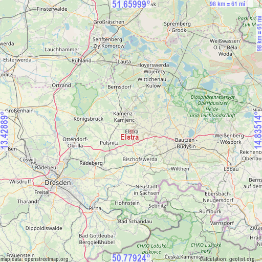
Elstra GPS coordinates[2]
51° 13' 18.192" North, 14° 7' 55.236" East
| Map corner | latitude | longitude |
|---|---|---|
| Upper-left | 51.65999°, | 13.42889° |
| Center: | 51.22172°, | 14.13201° |
| Lower-right: | 50.77924°, | 14.83514° |
| Map W x H: | 97.9×97.9 km | = 60.8×60.8mi |
| max Lat: | 55.01917° ⇑38.2% North |
| Elstra: | 51.22172° |
| min Lat: | ⇓61.8% South 47.40724° |
| min Long | Elstra | max Long |
| 5.92978° | 14.13201° | 14.98853° |
| W 98.4%⇐ | ⇒1.6% E |
Elevation
Elevation of Elstra is 220 m = 722 ft, and this is 29.1 m = 95 ft below average elevation for this country.
| Max E: |
1256 m = 4121 ft | 50.7% |
| Avg. | 249.1 m = 817 ft | |
| Elstra | 220 m = 722 ft | |
Min E: |
-5 m = -16 ft | 49.3% |
See also: Germany elevation on elevation.city.
Geographical zone
Elstra is located in North temperate zone (between Tropic of Cancer and the Arctic Circle). Distance of this North polar circle is 1705.9 km =1060 mi to North.| Distance of | km | miles | from Elstra |
|---|---|---|---|
| North Pole | 4311.7 | 2679.2 | to North |
| Arctic Circle | 1705.9 | 1060 | to North |
| Tropic Cancer | 3089.4 | 1919.7 | to South |
| Equator | 5695.3 | 3538.9 | to South |


Nearby cities:
15 places around Elstra: (largest is in red/bold)
• Bischofswerda
11 km =6.8 mi,  162°
162°
• Burkau
5.9 km =3.7 mi,  150°
150°
• Crostwitz
8 km =5 mi,  76°
76°
• Frankenthal
10.2 km =6.3 mi,  189°
189°
• Haselbachtal
7.6 km =4.7 mi,  281°
281°
• Hauswalde
8.4 km =5.2 mi,  202°
202°
• Horka
9.8 km =6.1 mi,  61°
61°
• Kamenz
5.8 km =3.6 mi,  332°
332°
• Nebelschütz
4.9 km =3 mi,  22°
22°
• Oberlichtenau
9.9 km =6.2 mi,  268°
268°
• Ohorn
8.1 km =5 mi,  227°
227°
• Panschwitz-Kuckau
4.8 km =3 mi,  73°
73°
• Rammenau
8 km =5 mi,  179°
179°
• Räckelwitz
7.7 km =4.8 mi, 65°
• Steina
6.2 km =3.9 mi,  247°
247°
Sources, notices
• [Note1] Compared only with cities in Germany existing in our database
• [Src1] Map data: © OpenStreetMap contributors (CC-BY-SA)
• [Src2] Other city data from geonames.org with taken over terms of usage.
• [Src3] Geographical zone / Annual Mean Temperature by Robert A. Rohde @ Wikipedia
