Höckendorf geodata
Höckendorf (Saxony) is a populated place; located in Germany in Europe/Berlin (GMT+2) time zone. With population of 3,156 people, there are 3867 cities with bigger population in this country. Compared to other cities in Germany, 61.9% of cities are located further ↓South; 97.6% of cities are located further ←West and 53.7% of cities have higher elevation than Höckendorf. Note1


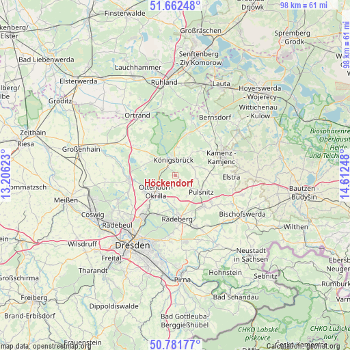
Höckendorf GPS coordinates[2]
51° 13' 27.228" North, 13° 54' 33.66" East
| Map corner | latitude | longitude |
|---|---|---|
| Upper-left | 51.66248°, | 13.20623° |
| Center: | 51.22423°, | 13.90935° |
| Lower-right: | 50.78177°, | 14.61248° |
| Map W x H: | 97.9×97.9 km | = 60.8×60.8mi |
| max Lat: | 55.01917° ⇑38.1% North |
| Höckendorf: | 51.22423° |
| min Lat: | ⇓61.9% South 47.40724° |
| min Long | Höckendorf | max Long |
| 5.92978° | 13.90935° | 14.98853° |
| W 97.6%⇐ | ⇒2.4% E |
Elevation
Elevation of Höckendorf is 199 m = 653 ft, and this is 50.1 m = 164 ft below average elevation for this country.
| Max E: |
1256 m = 4121 ft | 53.7% |
| Avg. | 249.1 m = 817 ft | |
| Höckendorf | 199 m = 653 ft | |
Min E: |
-5 m = -16 ft | 46.3% |
See also: Germany elevation on elevation.city.
Geographical zone
Höckendorf is located in North temperate zone (between Tropic of Cancer and the Arctic Circle). Distance of this North polar circle is 1705.6 km =1059.8 mi to North.| Distance of | km | miles | from Höckendorf |
|---|---|---|---|
| North Pole | 4311.5 | 2679 | to North |
| Arctic Circle | 1705.6 | 1059.8 | to North |
| Tropic Cancer | 3089.7 | 1919.8 | to South |
| Equator | 5695.6 | 3539.1 | to South |


Nearby cities:
15 places around Höckendorf: (largest is in red/bold)
• Feldschlößchen
9.5 km =5.9 mi,  177°
177°
• Großnaundorf
3.2 km =2 mi,  148°
148°
• Großröhrsdorf
11.6 km =7.2 mi,  138°
138°
• Haselbachtal
8.2 km =5.1 mi,  81°
81°
• Königsbrück
4.5 km =2.8 mi,  356°
356°
• Laußnitz
3.4 km =2.1 mi,  327°
327°
• Lichtenberg
6.1 km =3.8 mi, 138°
• Neukirch
8.3 km =5.2 mi,  38°
38°
• Oberlichtenau
5.6 km =3.5 mi,  96°
96°
• Ohorn
11.2 km =7 mi,  121°
121°
• Ottendorf-Okrilla
7 km =4.3 mi,  229°
229°
• Schwepnitz
12 km =7.5 mi,  16°
16°
• Steina
10.2 km =6.3 mi,  105°
105°
• Tauscha
9 km =5.6 mi,  301°
301°
• Wachau
7 km =4.3 mi, 181°
Sources, notices
• [Note1] Compared only with cities in Germany existing in our database
• [Src1] Map data: © OpenStreetMap contributors (CC-BY-SA)
• [Src2] Other city data from geonames.org with taken over terms of usage.
• [Src3] Geographical zone / Annual Mean Temperature by Robert A. Rohde @ Wikipedia
