Kamenz geodata
Kamenz (Saxony) is a populated place; located in Germany in Europe/Berlin (GMT+2) time zone. With population of 18,270 people, there are 861 cities with bigger population in this country. Compared to other cities in Germany, 62.8% of cities are located further ↓South; 98.3% of cities are located further ←West and 53.4% of cities have higher elevation than Kamenz. Note1


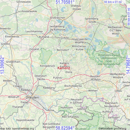
Kamenz GPS coordinates[2]
51° 16' 4.728" North, 14° 5' 37.464" East
| Map corner | latitude | longitude |
|---|---|---|
| Upper-left | 51.70581°, | 13.39062° |
| Center: | 51.26798°, | 14.09374° |
| Lower-right: | 50.82594°, | 14.79687° |
| Map W x H: | 97.8×97.8 km | = 60.8×60.8mi |
| max Lat: | 55.01917° ⇑37.2% North |
| Kamenz: | 51.26798° |
| min Lat: | ⇓62.8% South 47.40724° |
| min Long | Kamenz | max Long |
| 5.92978° | 14.09374° | 14.98853° |
| W 98.3%⇐ | ⇒1.7% E |
Elevation
Elevation of Kamenz is 201 m = 659 ft, and this is 48.1 m = 158 ft below average elevation for this country.
| Max E: |
1256 m = 4121 ft | 53.4% |
| Avg. | 249.1 m = 817 ft | |
| Kamenz | 201 m = 659 ft | |
Min E: |
-5 m = -16 ft | 46.6% |
See also: Germany elevation on elevation.city.
Geographical zone
Kamenz is located in North temperate zone (between Tropic of Cancer and the Arctic Circle). Distance of this North polar circle is 1700.7 km =1056.8 mi to North.| Distance of | km | miles | from Kamenz |
|---|---|---|---|
| North Pole | 4306.6 | 2676 | to North |
| Arctic Circle | 1700.7 | 1056.8 | to North |
| Tropic Cancer | 3094.5 | 1922.8 | to South |
| Equator | 5700.5 | 3542.1 | to South |


Nearby cities:
15 places around Kamenz: (largest is in red/bold)
• Burkau
11.7 km =7.3 mi,  151°
151°
• Crostwitz
10.9 km =6.8 mi,  107°
107°
• Elstra
5.8 km =3.6 mi, 152°
• Haselbachtal
5.9 km =3.7 mi,  232°
232°
• Horka
11.2 km =7 mi,  92°
92°
• Nebelschütz
4.5 km =2.8 mi,  98°
98°
• Neukirch
7.9 km =4.9 mi,  282°
282°
• Oberlichtenau
9.1 km =5.7 mi, 232°
• Ohorn
11.2 km =7 mi,  197°
197°
• Oßling
11.4 km =7.1 mi,  26°
26°
• Panschwitz-Kuckau
8.2 km =5.1 mi,  117°
117°
• Räckelwitz
9.9 km =6.2 mi, 101°
• Schwepnitz
11.6 km =7.2 mi,  305°
305°
• Steina
8.1 km =5 mi, 201°
• Straßgräbchen
9.6 km =6 mi,  347°
347°
Sources, notices
• [Note1] Compared only with cities in Germany existing in our database
• [Src1] Map data: © OpenStreetMap contributors (CC-BY-SA)
• [Src2] Other city data from geonames.org with taken over terms of usage.
• [Src3] Geographical zone / Annual Mean Temperature by Robert A. Rohde @ Wikipedia
