Starkenburg geodata
Starkenburg (Rheinland-Pfalz) is a seat of a fourth-order administrative division; located in Germany in Europe/Berlin (GMT+2) time zone. With population of 252 people, there are 10253 cities with bigger population in this country. Compared to other cities in Germany, 64.8% of cities are located further ↑North; 92.1% of cities are located further →East and 68.3% of cities have higher elevation than Starkenburg. Note1
Administrative division(s):
- Level 1: Rheinland-Pfalz
- Level 3: Landkreis Bernkastel-Wittlich
- Level 4: Starkenburg


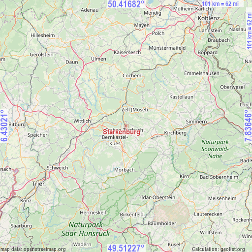
Starkenburg GPS coordinates[2]
49° 58' 0.012" North, 7° 7' 59.988" East
| Map corner | latitude | longitude |
|---|---|---|
| Upper-left | 50.41682°, | 6.43021° |
| Center: | 49.96667°, | 7.13333° |
| Lower-right: | 49.51227°, | 7.83646° |
| Map W x H: | 100.6×100.6 km | = 62.5×62.5mi |
| max Lat: | 55.01917° ⇑64.8% North |
| Starkenburg: | 49.96667° |
| min Lat: | ⇓35.2% South 47.40724° |
| min Long | Starkenburg | max Long |
| 5.92978° | 7.13333° | 14.98853° |
| W 7.9%⇐ | ⇒92.1% E |
Elevation
Elevation of Starkenburg is 101 m = 331 ft, and this is 148.1 m = 486 ft below average elevation for this country.
| Max E: |
1256 m = 4121 ft | 68.3% |
| Avg. | 249.1 m = 817 ft | |
| Starkenburg | 101 m = 331 ft | |
Min E: |
-5 m = -16 ft | 31.7% |
See also: Germany elevation on elevation.city.
Geographical zone
Starkenburg is located in North temperate zone (between Tropic of Cancer and the Arctic Circle). Distance of this North polar circle is 1845.4 km =1146.7 mi to North.| Distance of | km | miles | from Starkenburg |
|---|---|---|---|
| North Pole | 4451.3 | 2765.9 | to North |
| Arctic Circle | 1845.4 | 1146.7 | to North |
| Tropic Cancer | 2949.9 | 1833 | to South |
| Equator | 5555.8 | 3452.2 | to South |


Nearby cities:
15 places around Starkenburg: (largest is in red/bold)
• Bengel
7.3 km =4.5 mi,  319°
319°
• Bernkastel-Kues
6.9 km =4.3 mi,  215°
215°
• Briedel
5.7 km =3.5 mi,  12°
12°
• Enkirch
2 km =1.2 mi,  353°
353°
• Graach
6.2 km =3.9 mi,  234°
234°
• Irmenach
6.2 km =3.9 mi,  140°
140°
• Kinheim
6 km =3.7 mi,  270°
270°
• Kleinich
8.2 km =5.1 mi,  154°
154°
• Kröv
4 km =2.5 mi,  297°
297°
• Lösnich
6.5 km =4 mi,  277°
277°
• Lötzbeuren
7 km =4.3 mi,  121°
121°
• Raversbeuren
7.4 km =4.6 mi,  104°
104°
• Reil
5.7 km =3.5 mi, 347°
• Traben-Trarbach
2.2 km =1.4 mi, 215°
• Zell
7.8 km =4.8 mi,  26°
26°
Sources, notices
• [Note1] Compared only with cities in Germany existing in our database
• [Src1] Map data: © OpenStreetMap contributors (CC-BY-SA)
• [Src2] Other city data from geonames.org with taken over terms of usage.
• [Src3] Geographical zone / Annual Mean Temperature by Robert A. Rohde @ Wikipedia
