Irmenach geodata
Irmenach (Rheinland-Pfalz) is a seat of a fourth-order administrative division; located in Germany in Europe/Berlin (GMT+2) time zone. With population of 748 people, there are 8109 cities with bigger population in this country. Compared to other cities in Germany, 65.7% of cities are located further ↑North; 91.5% of cities are located further →East and 82.4% of cities have lower elevation than Irmenach. Note1
Administrative division(s):
- Level 1: Rheinland-Pfalz
- Level 3: Landkreis Bernkastel-Wittlich
- Level 4: Irmenach


Irmenach GPS coordinates[2]
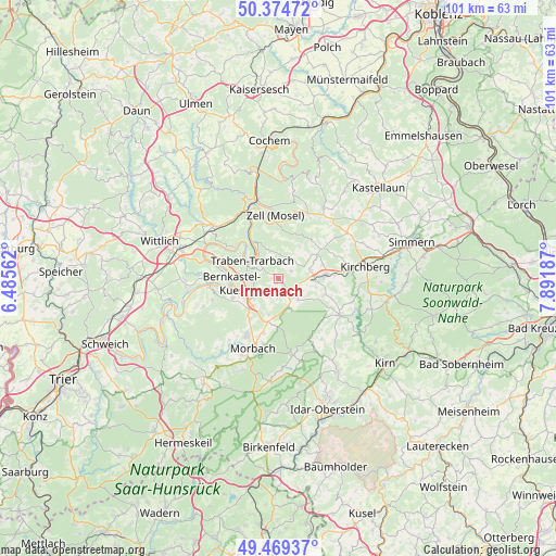
49° 55' 27.012" North, 7° 11' 19.464" East
| Map corner | latitude | longitude |
|---|---|---|
| Upper-left | 50.37472°, | 6.48562° |
| Center: | 49.92417°, | 7.18874° |
| Lower-right: | 49.46937°, | 7.89187° |
| Map W x H: | 100.7×100.7 km | = 62.6×62.6mi |
| max Lat: | 55.01917° ⇑65.7% North |
| Irmenach: | 49.92417° |
| min Lat: | ⇓34.3% South 47.40724° |
| min Long | Irmenach | max Long |
| 5.92978° | 7.18874° | 14.98853° |
| W 8.5%⇐ | ⇒91.5% E |
Elevation
Elevation of Irmenach is 449 m = 1473 ft, and this is 199.9 m = 656 ft above average elevation for this country.
| Max E: |
1256 m = 4121 ft | 17.6% |
| Irmenach | 449 m 1473 ft | |
| Avg. | 249.1 m = 817 ft | |
Min E: |
-5 m = -16 ft | 82.4% |
See also: Germany elevation on elevation.city.
Geographical zone
Irmenach is located in North temperate zone (between Tropic of Cancer and the Arctic Circle). Distance of this North polar circle is 1850.1 km =1149.6 mi to North.| Distance of | km | miles | from Irmenach |
|---|---|---|---|
| North Pole | 4456 | 2768.8 | to North |
| Arctic Circle | 1850.1 | 1149.6 | to North |
| Tropic Cancer | 2945.1 | 1830 | to South |
| Equator | 5551 | 3449.2 | to South |


Nearby cities:
15 places around Irmenach: (largest is in red/bold)
• Büchenbeuren
6.5 km =4 mi,  93°
93°
• Hahn
7.3 km =4.5 mi,  49°
49°
• Hochscheid
5 km =3.1 mi,  156°
156°
• Horbruch
5.6 km =3.5 mi,  144°
144°
• Kleinich
2.7 km =1.7 mi,  188°
188°
• Kommen
6 km =3.7 mi,  221°
221°
• Krummenau
7.2 km =4.5 mi,  129°
129°
• Lautzenhausen
5.7 km =3.5 mi,  79°
79°
• Longkamp
6.3 km =3.9 mi,  233°
233°
• Lötzbeuren
2.2 km =1.4 mi,  63°
63°
• Niederweiler
7.3 km =4.5 mi,  111°
111°
• Raversbeuren
4.3 km =2.7 mi, 48°
• Starkenburg
6.2 km =3.9 mi,  320°
320°
• Traben-Trarbach
6 km =3.7 mi,  299°
299°
• Wahlenau
5.1 km =3.2 mi,  121°
121°
Sources, notices
• [Note1] Compared only with cities in Germany existing in our database
• [Src1] Map data: © OpenStreetMap contributors (CC-BY-SA)
• [Src2] Other city data from geonames.org with taken over terms of usage.
• [Src3] Geographical zone / Annual Mean Temperature by Robert A. Rohde @ Wikipedia
