Lankwitz geodata
Lankwitz (Berlin) is a section of populated place; located in Germany in Europe/Berlin (GMT+2) time zone. With population of 41,242 people, there are 307 cities with bigger population in this country. Compared to other cities in Germany, 76.7% of cities are located further ↓South; 94.7% of cities are located further ←West and 81.4% of cities have higher elevation than Lankwitz. Note1


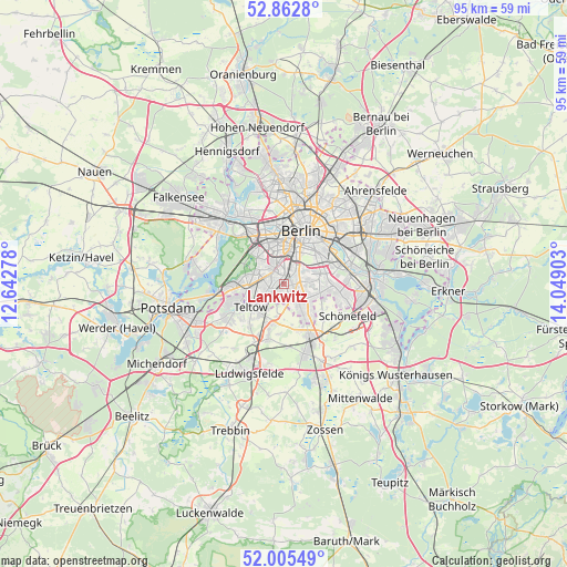
Lankwitz GPS coordinates[2]
52° 26' 10.428" North, 13° 20' 45.24" East
| Map corner | latitude | longitude |
|---|---|---|
| Upper-left | 52.8628°, | 12.64278° |
| Center: | 52.43623°, | 13.3459° |
| Lower-right: | 52.00549°, | 14.04903° |
| Map W x H: | 95.3×95.3 km | = 59.2×59.2mi |
| max Lat: | 55.01917° ⇑23.3% North |
| Lankwitz: | 52.43623° |
| min Lat: | ⇓76.7% South 47.40724° |
| min Long | Lankwitz | max Long |
| 5.92978° | 13.3459° | 14.98853° |
| W 94.7%⇐ | ⇒5.3% E |
Elevation
Elevation of Lankwitz is 43 m = 141 ft, and this is 206.1 m = 676 ft below average elevation for this country.
| Max E: |
1256 m = 4121 ft | 81.4% |
| Avg. | 249.1 m = 817 ft | |
| Lankwitz | 43 m = 141 ft | |
Min E: |
-5 m = -16 ft | 18.6% |
See also: Lankwitz elevation on elevation.city.
Geographical zone
Lankwitz is located in North temperate zone (between Tropic of Cancer and the Arctic Circle). Distance of this North polar circle is 1570.8 km =976 mi to North.| Distance of | km | miles | from Lankwitz |
|---|---|---|---|
| North Pole | 4176.7 | 2595.3 | to North |
| Arctic Circle | 1570.8 | 976 | to North |
| Tropic Cancer | 3224.4 | 2003.5 | to South |
| Equator | 5830.4 | 3622.8 | to South |


Nearby cities:
15 places around Lankwitz: (largest is in red/bold)
• Britz
6 km =3.7 mi,  82°
82°
• Dahlem
4.7 km =2.9 mi,  301°
301°
• Friedenau
4.1 km =2.5 mi,  342°
342°
• Halensee
6.9 km =4.3 mi,  330°
330°
• Lichtenrade
5.9 km =3.7 mi,  135°
135°
• Lichterfelde
2.6 km =1.6 mi,  262°
262°
• Mariendorf
2.4 km =1.5 mi,  85°
85°
• Marienfelde
2.4 km =1.5 mi, 143°
• Schmargendorf
5.7 km =3.5 mi,  319°
319°
• Schöneberg
3.4 km =2.1 mi,  4°
4°
• Steglitz
2.4 km =1.5 mi, 336°
• Teltow
6.9 km =4.3 mi,  237°
237°
• Tempelhof
5 km =3.1 mi,  47°
47°
• Wilmersdorf
5.6 km =3.5 mi, 339°
• Zehlendorf
6.5 km =4 mi,  267°
267°
Sources, notices
• [Note1] Compared only with cities in Germany existing in our database
• [Src1] Map data: © OpenStreetMap contributors (CC-BY-SA)
• [Src2] Other city data from geonames.org with taken over terms of usage.
• [Src3] Geographical zone / Annual Mean Temperature by Robert A. Rohde @ Wikipedia
