Stadtroda geodata
Stadtroda (Thuringia) is a populated place; located in Germany in Europe/Berlin (GMT+2) time zone. With population of 6,695 people, there are 2258 cities with bigger population in this country. Compared to other cities in Germany, 55.3% of cities are located further ↓South; 77.6% of cities are located further ←West and 53.7% of cities have higher elevation than Stadtroda. Note1


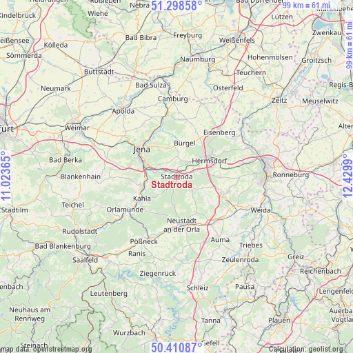
Stadtroda GPS coordinates[2]
50° 51' 24.624" North, 11° 43' 36.372" East
| Map corner | latitude | longitude |
|---|---|---|
| Upper-left | 51.29858°, | 11.02365° |
| Center: | 50.85684°, | 11.72677° |
| Lower-right: | 50.41087°, | 12.4299° |
| Map W x H: | 98.7×98.7 km | = 61.3×61.3mi |
| max Lat: | 55.01917° ⇑44.7% North |
| Stadtroda: | 50.85684° |
| min Lat: | ⇓55.3% South 47.40724° |
| min Long | Stadtroda | max Long |
| 5.92978° | 11.72677° | 14.98853° |
| W 77.6%⇐ | ⇒22.4% E |
Elevation
Elevation of Stadtroda is 199 m = 653 ft, and this is 50.1 m = 164 ft below average elevation for this country.
| Max E: |
1256 m = 4121 ft | 53.7% |
| Avg. | 249.1 m = 817 ft | |
| Stadtroda | 199 m = 653 ft | |
Min E: |
-5 m = -16 ft | 46.3% |
See also: Germany elevation on elevation.city.
Geographical zone
Stadtroda is located in North temperate zone (between Tropic of Cancer and the Arctic Circle). Distance of this North polar circle is 1746.4 km =1085.2 mi to North.| Distance of | km | miles | from Stadtroda |
|---|---|---|---|
| North Pole | 4352.3 | 2704.4 | to North |
| Arctic Circle | 1746.4 | 1085.2 | to North |
| Tropic Cancer | 3048.8 | 1894.4 | to South |
| Equator | 5654.8 | 3513.7 | to South |


Nearby cities:
15 places around Stadtroda: (largest is in red/bold)
• Geisenhain
2.7 km =1.7 mi,  195°
195°
• Gneus
5.4 km =3.4 mi,  214°
214°
• Kleinbockedra
5.4 km =3.4 mi,  261°
261°
• Laasdorf
4.1 km =2.5 mi,  292°
292°
• Meusebach
4.5 km =2.8 mi,  174°
174°
• Möckern
2.9 km =1.8 mi,  105°
105°
• Mörsdorf
5.2 km =3.2 mi,  73°
73°
• Quirla
3 km =1.9 mi, 68°
• Rattelsdorf
5.3 km =3.3 mi,  147°
147°
• Rausdorf
3.2 km =2 mi, 289°
• Ruttersdorf-Lotschen
3 km =1.9 mi,  8°
8°
• Schlöben
4.9 km =3 mi,  327°
327°
• Tissa
1.8 km =1.1 mi,  115°
115°
• Tröbnitz
2.7 km =1.7 mi, 170°
• Waltersdorf
3.1 km =1.9 mi, 148°
Sources, notices
• [Note1] Compared only with cities in Germany existing in our database
• [Src1] Map data: © OpenStreetMap contributors (CC-BY-SA)
• [Src2] Other city data from geonames.org with taken over terms of usage.
• [Src3] Geographical zone / Annual Mean Temperature by Robert A. Rohde @ Wikipedia
