Kleinbockedra geodata
Kleinbockedra (Thuringia) is a seat of a fourth-order administrative division; located in Germany in Europe/Berlin (GMT+2) time zone. With population of 46 people, there are 10971 cities with bigger population in this country. Compared to other cities in Germany, 55% of cities are located further ↓South; 76.4% of cities are located further ←West and 52.5% of cities have lower elevation than Kleinbockedra. Note1


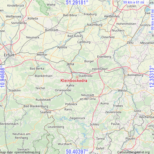
Kleinbockedra GPS coordinates[2]
50° 51' 0" North, 11° 39' 0" East
| Map corner | latitude | longitude |
|---|---|---|
| Upper-left | 51.29181°, | 10.94688° |
| Center: | 50.85°, | 11.65° |
| Lower-right: | 50.40397°, | 12.35313° |
| Map W x H: | 98.7×98.7 km | = 61.3×61.3mi |
| max Lat: | 55.01917° ⇑45% North |
| Kleinbockedra: | 50.85° |
| min Lat: | ⇓55% South 47.40724° |
| min Long | Kleinbockedra | max Long |
| 5.92978° | 11.65° | 14.98853° |
| W 76.4%⇐ | ⇒23.6% E |
Elevation
Elevation of Kleinbockedra is 243 m = 797 ft, and this is 6.1 m = 20 ft below average elevation for this country.
| Max E: |
1256 m = 4121 ft | 47.5% |
| Avg. | 249.1 m = 817 ft | |
| Kleinbockedra | 243 m = 797 ft | |
Min E: |
-5 m = -16 ft | 52.5% |
See also: Germany elevation on elevation.city.
Geographical zone
Kleinbockedra is located in North temperate zone (between Tropic of Cancer and the Arctic Circle). Distance of this North polar circle is 1747.2 km =1085.7 mi to North.| Distance of | km | miles | from Kleinbockedra |
|---|---|---|---|
| North Pole | 4353.1 | 2704.9 | to North |
| Arctic Circle | 1747.2 | 1085.7 | to North |
| Tropic Cancer | 3048.1 | 1894 | to South |
| Equator | 5654 | 3513.2 | to South |


Nearby cities:
15 places around Kleinbockedra: (largest is in red/bold)
• Geisenhain
5 km =3.1 mi,  111°
111°
• Gneus
4.4 km =2.7 mi,  147°
147°
• Großbockedra
0 km =0 mi,  0°
0°
• Großpürschütz
5.1 km =3.2 mi,  223°
223°
• Laasdorf
2.9 km =1.8 mi,  33°
33°
• Oberbodnitz
5.7 km =3.5 mi,  168°
168°
• Rausdorf
3 km =1.9 mi,  51°
51°
• Rothenstein
3.5 km =2.2 mi,  270°
270°
• Schlöben
5.6 km =3.5 mi, 29°
• Schöps
4 km =2.5 mi,  242°
242°
• Seitenroda
6 km =3.7 mi,  202°
202°
• Stadtroda
5.4 km =3.4 mi,  81°
81°
• Sulza
3 km =1.9 mi,  308°
308°
• Unterbodnitz
3.7 km =2.3 mi,  180°
180°
• Zöllnitz
2.7 km =1.7 mi,  346°
346°
Sources, notices
• [Note1] Compared only with cities in Germany existing in our database
• [Src1] Map data: © OpenStreetMap contributors (CC-BY-SA)
• [Src2] Other city data from geonames.org with taken over terms of usage.
• [Src3] Geographical zone / Annual Mean Temperature by Robert A. Rohde @ Wikipedia
